MAKE A MEME
View Large Image
| View Original: | EB_1911_Map_Fig_8.png (2300x2790) | |||
| Download: | Original | Medium | Small | Thumb |
| Courtesy of: | commons.wikimedia.org | More Like This | ||
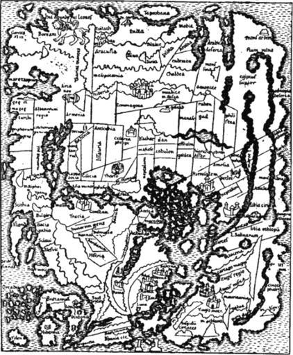
| Keywords: EB 1911 Map Fig 8.png Fig 8 ”Anglo-Saxon Map of the World 9th century <br>From a Cotton MS In Latin with East India and Taprobane/Sri Lanka at the top of the map 1911 Map in the Encyclopaedia Britannica 11th ed Vol XVII p 638 anonymous Presumably Emery Walker PD-US; PD-Britannica; PD-Art other versions <gallery> Cotton world map jpg Original map </gallery> PD-US PD-Art PD-100 PD-Britannica 9th-century maps Maps in Latin Maps of Eurasia 1911 maps DEFAULTSORT ENCYCLOPAEDIA BRITANNICA 1911 17 MAP 08 Images from the 1911 Encyclopædia Britannica volume 17 Map 08 Cotton Mappa Mundi ImageNote 1 1117 75 228 75 2300 2790 2 Taprobana Sri Lanka ImageNoteEnd 1 ImageNote 2 1015 633 205 154 2300 2790 2 Babilonia Babylon ImageNoteEnd 2 ImageNote 3 531 1667 144 65 2300 2790 2 Tracia Thrace ImageNoteEnd 3 ImageNote 4 98 1579 149 65 2300 2790 2 Scithia Scythia ImageNoteEnd 4 ImageNote 5 1089 2203 149 116 2300 2790 2 Roma Rome ImageNoteEnd 5 ImageNote 6 1490 1341 228 168 2300 2790 2 Hierasalem Jerusalem ImageNoteEnd 6 | ||||