MAKE A MEME
View Large Image
| View Original: | David_Livingstone's_Map_of_Lake_Malawi,_Africa.jpg (800x953) | |||
| Download: | Original | Medium | Small | Thumb |
| Courtesy of: | www.flickr.com | More Like This | ||
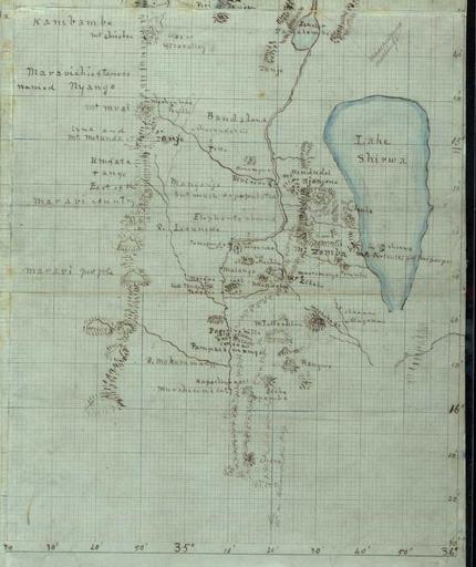
| Keywords: david livingstone davidlivingstone map africa lake lake malawi lakemalawi drawing malawi nls texture text sketch writing document This map of Lake Malawi (formerly Nyasa) was made around 1863 by Dr David Livingstone. Livingstone drew his map during his ambitious government-funded expedition exhibition of 1859-63, which aimed to establish the navigability of the Zambesi river. Navigation into the interior proved impossible, but much useful scientific and geographical work was done. This may have been recorded to aid his reports and later narratives of his expeditions or to provide information for missionaries and European traders - 'Christianity and commerce' - who might follow him to develop the area or to banish the slave trade that so disrupted society in this part of Africa. More .... This map of Lake Malawi (formerly Nyasa) was made around 1863 by Dr David Livingstone. Livingstone drew his map during his ambitious government-funded expedition exhibition of 1859-63, which aimed to establish the navigability of the Zambesi river. Navigation into the interior proved impossible, but much useful scientific and geographical work was done. This may have been recorded to aid his reports and later narratives of his expeditions or to provide information for missionaries and European traders - 'Christianity and commerce' - who might follow him to develop the area or to banish the slave trade that so disrupted society in this part of Africa. More .... | ||||