MAKE A MEME
View Large Image
| View Original: | Cotabato_1918.jpg (677x1168) | |||
| Download: | Original | Medium | Small | Thumb |
| Courtesy of: | commons.wikimedia.org | More Like This | ||
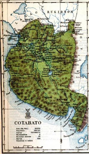
| Keywords: Cotabato 1918.jpg es Siendo Cotabato una de las provincias de mayor extensión superficial de todo el archipiélago 24 916 km² incluyendo la isla de Bongo contaba solamente con el municipio que la daba nombre creado el 1 de septiembre de 1914 2014-01-01 13 38 20 Census of the Philippine Islands taken under the Direction of the Philippine Legislature in the year 1918 Volume I Geography History and Climatology Compiled and published by the Census Office of the Philippine Islands Manila Bureau of Printing 1920 Ignacio Villamor Director PD-USGov Uploaded with UploadWizard Old maps of the Philippines Old maps of Mindanao 1918 Census of the Philippine Islands maps | ||||