MAKE A MEME
View Large Image
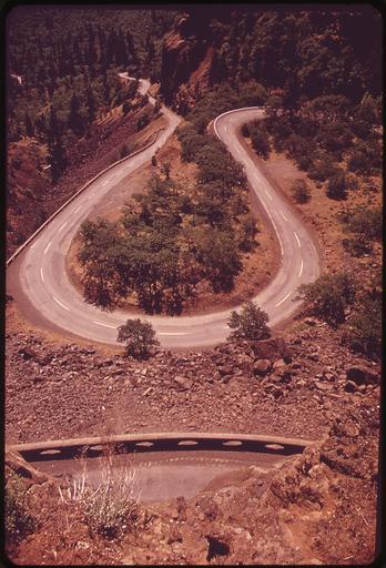
| View Original: | COLUMBIA_RIVER_GORGE_LOOKING_WEST_FROM_THE_SUMMIT_OF_ROWENA_HILLS_BETWEEN_MOSIER_AND_THE_HOOD_RIVER._BELOW,_ROUTE_80N..._-_NARA_-_548099.jpg (2039x3000) | |||
| Download: | Original | Medium | Small | Thumb |
| Courtesy of: | commons.wikimedia.org | More Like This | ||
| Keywords: COLUMBIA RIVER GORGE LOOKING WEST FROM THE SUMMIT OF ROWENA HILLS BETWEEN MOSIER AND THE HOOD RIVER. BELOW, ROUTE 80N... - NARA - 548099.jpg Scope and content General notes 548099 Local identifier 412-DA-5612 Environmental Protection Agency 12/02/1970 - NARA-Author Falconer David Photographer 1427627 <br /> The Dalles Wasco county Oregon United States North and Central America inhabited place 3374789 45 583 -121 17 <br /> Still Picture Records Section Special Media Archives Services Division NWCS-S National Archives at College Park 8601 Adelphi Road College Park MD 20740-6001 05/1973 Record group Record Group 412 Records of the Environmental Protection Agency 1944 - 2006 Record group ARC 708 DOCUMERICA The Environmental Protection Agency's Program to Photographically Document Subjects of Environmental Concern compiled 1972 - 1977 Series ARC 542493 File unit File unit ARC Variant control numbers Agency-Assigned Identifier 094/32/005612<br /> NAIL Control Number NWDNS-412-DA-5612 Other versions <gallery> File COLUMBIA_RIVER_GORGE_LOOKING_WEST_FROM_THE_SUMMIT_OF_ROWENA_HILLS_BETWEEN_MOSIER_AND_THE_HOOD_RIVER _BELOW _ROUTE_80N _-_NARA_-_548099 tif tif File COLUMBIA_RIVER_GORGE_LOOKING_WEST_FROM_THE_SUMMIT_OF_ROWENA_HILLS_BETWEEN_MOSIER_AND_THE_HOOD_RIVER _BELOW _ROUTE_80N _-_NARA_-_548099 jpg jpg </gallery> NARA-cooperation PD-USGov Rowena Loops May 1973 in the United States 1973 in Oregon Hairpin turns | ||||