MAKE A MEME
View Large Image
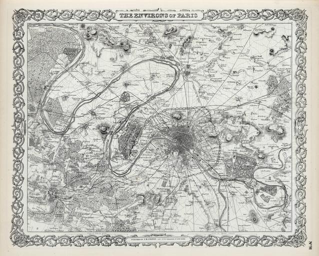
| View Original: | Colton,_The_Environs_of_Paris,_1865_-_David_Rumsey.jpg (6152x4939) | |||
| Download: | Original | Medium | Small | Thumb |
| Courtesy of: | commons.wikimedia.org | More Like This | ||
| Keywords: Colton, The Environs of Paris, 1865 - David Rumsey.jpg 1865 Map printed in black and white Size cm 40 33 David Rumsey Historical Map Collection object history exhibition history credit line Scale 1 97 000 Relief shown by hachures <br/> Has letter from J H Colton to his Pastor tipped in Phillips shows 1860 and 1864 editions with none in between Colton might not have published the General Atlas in this period because of the Family Atlas collaboration with Johnson just saw an 1862 1863 listed in World - Brit Museum but maybe small editions were run That collaboration ended in 1863 we believe when Colton's name was dropped from the direct title page credits Ristow states p325 that Colton retired in 1864 and the General Atlas thereafter was published by G W C B Phillips does not list this 1865 which has J H as publisher but has 1866 P6155 published by G W C B Colton adds the Johnson western states maps in this edition and may have done this also in 1864 while Johnson drops them in 1864 and replaces them with maps of unknown source Full color used to differentiate the political boundaries accession number place of creation http //www davidrumsey com/luna/servlet/detail/RUMSEY~8~1~208800~5003462 David Rumsey Historical Map Collection PD-100 Maps of Paris in the 19th century 19th-century maps of Paris David Rumsey Historical Map Collection 1865 in Paris 1865 maps | ||||