MAKE A MEME
View Large Image
| View Original: | Centro-old-map.jpg (634x1503) | |||
| Download: | Original | Medium | Small | Thumb |
| Courtesy of: | commons.wikimedia.org | More Like This | ||
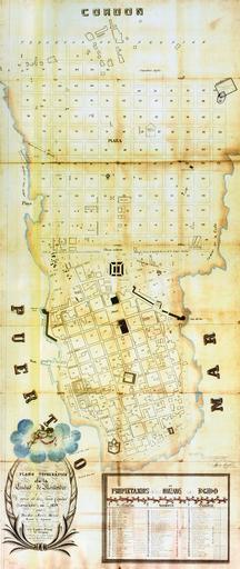
| Keywords: Centro-old-map.jpg 1829 map of the Ciudad Nueva of Montevideo Uruguay In that year the National Assembly decided to pull down the fortifiactions of the Ciudad Vieja and extend the city to form the Ciudad Nueva The tracing project was given to military engineer Don José María Reyes In our times the extension is the barrio Centro of Montevideo Archivo Gráfico de Planos de Mensura Montevideo Uruguay 1829 Don José María Reyes PD-Uruguay PD-old Old maps of barrios of Montevideo Centro Montevideo Ciudad Vieja 1829 in Uruguay | ||||