MAKE A MEME
View Large Image
| View Original: | Borinage_sud_1933_afgeleid.jpg (6881x4873) | |||
| Download: | Original | Medium | Small | Thumb |
| Courtesy of: | commons.wikimedia.org | More Like This | ||
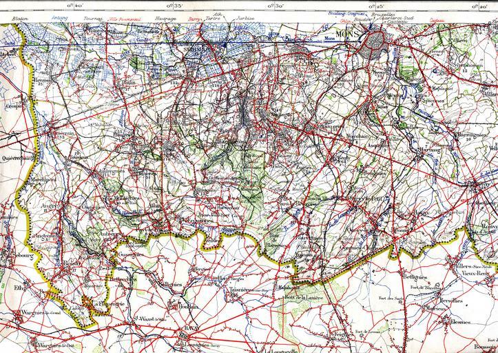
| Keywords: Borinage sud 1933 afgeleid.jpg en The region around Mons and the French border in 1933 This shows the railways and trams around that time This military staff map was cut up and pasted on a canvas <br> Railway lines are black lines with marks on one side Smalltrack is a thinner line If there are marks on both sides it is double track nl De streek rond Bergen Borinage en de Franse grens in 1933 De spoorwegen en buurtspoorwegen zijn te herkennen Borinage_sud_1933_orig jpg 2010-06-30 15 34 UTC Borinage_sud_1933_orig jpg L'Institut Cartographique Militaire Belgian army derivative work Brbbl <span class signature-talk >talk</span> Borinage_sud_1933_orig jpg PD-old original upload log This image is a derivative work of the following images File Borinage_sud_1933_orig jpg licensed with PD-old 2010-06-06T21 21 24Z Smiley toerist 7019x4893 17346341 Bytes <nowiki> en The region around Mons and the French border in 1933 This shows the railways and trams around that time This militairy staf map was cut upp and pasted on a canvas nl De streek rond B</nowiki> Uploaded with derivativeFX 1933 Old maps of Hainaut Old maps of Mons Hainaut Public transport maps of the SNCV / NMVB Hainaut Borinage Rail transport maps of Belgium Maps of the Borinage 1933 in tram transport | ||||