MAKE A MEME
View Large Image
| View Original: | Bayshore Highway at Sierra Point 1929.jpg (640x480) | |||
| Download: | Original | Medium | Small | Thumb |
| Courtesy of: | commons.wikimedia.org | More Like This | ||
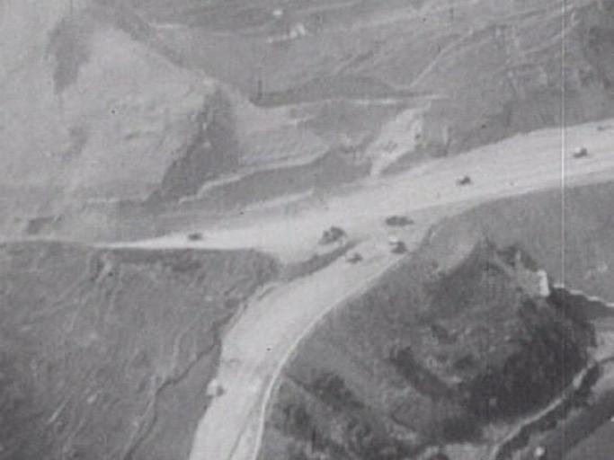
| Keywords: Bayshore Highway at Sierra Point 1929.jpg Prelinger This is an aerial view looking west at 37 67550 N 122 39104 W in 1929 at the then-new Bayshore Highway now Bayshore Boulevard at Sierra Point in Brisbane San Mateo County California The old road is in the foreground and the new road cuts through the hill a forerunner of U S Route 101 The tunnel on the Southern Pacific Railroad's 1907 Bayshore Cut-Off of the Coast Line now Caltrain on the right no longer exists as most of the land east of the 1929 Bayshore Highway has been cut down video from the http //www archive org/details/Californ1929 Prelinger Archives 1929 author the Internet Archive says it's public domain offsite http //sunsite2 berkeley edu/lizardtech/iserv/calcrgn cat histopo item brk00000137_10a sid wid 600 hei 500 style generic/view xsl plugin true 1939 map http //maps live com/default aspx v 2 cp q8c7tz4t0nsb style o lvl 1 tilt -90 dir 0 alt -1000 scene 7777371 encType 1 current bird's eye view Rail tunnels in California U S Route 101 in California Brisbane California Aerial photographs of San Francisco 1929 in California Peninsula Commute | ||||