MAKE A MEME
View Large Image
| View Original: | Atlas_Van_der_Hagen-KW1049B11_060-MARCHIONATUS_SACRI_ROMANI_IMPERII.jpeg (5500x4582) | |||
| Download: | Original | Medium | Small | Thumb |
| Courtesy of: | commons.wikimedia.org | More Like This | ||
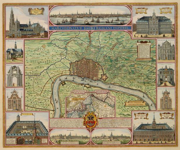
| Keywords: Atlas Van der Hagen-KW1049B11 060-MARCHIONATUS SACRI ROMANI IMPERII.jpeg of the Atlas Van der Hagen in the catalogue of the KB http //opc4 kb nl/DB 1/TTL 1/LNG EN/PPN PPN 353012750 Claes Jansz Visscher Author Claes Jansz Visscher Publisher Claes Jansz Visscher Author Claes Jansz Visscher Publisher Claes Jansz Visscher credit line 1624 Deze fraaie kaart toont de stad Antwerpen en het markgraafschap en tevens de belangrijkste gebouwen De kaart werd in 1624 gegraveerd en uitgegeven door Claes Jansz Visscher 1587-1652 in Amsterdam Hoewel de afbeelding van de voornaamste kerken en stadspoorten aan de kaart een toeristisch karakter suggereert werd de kaart waarschijnlijk gepubliceerd naar aanleiding van de vergeefse belegeringen van de stad aan de Schelde in 1620 en 1624 door Prins Maurits In zijn toelichting op het inzetkaartje waarin de loop van de Schelde wordt afgebeeld vestigt Visscher vooral de nadruk op de militaire versterkingen en de cruciale dijken rondom de stad De Schelde vormde bij belegeringen van de stad een cruciale schakel ; Op de kaart een stadsgezicht en een aantal inzetten met de belangrijkste gebouwen This particularly beautifully decorated map shows the city of Antwerp and surroundings and the most important buildings The map was engraved and published by Claes Jansz Visscher 1587-1652 in Amsterdam in 1624 Although the pictures of the churches and important monumental buildings suggest a touristic character the map was probable published after some sieges of the city by Prince Maurits at the river Schelde in 1620 en 1624 Text in the inset with the course of the river Schelde emphasizes the military fortifications and the crucial role of the dikes around the city The river Schelde appeared to be a strategic point when the city was besieged 45 8 x 55 8 cm exhibition history Institution Koninklijke Bibliotheek kopergravure Technique copper engraving KW1049B11_060 - Volume 1 Claes Jansz Visscher - Maurits prins van Oranje-Nassau Information field Depicted locations Antwerp - Belgium - Schelde river object history object type Prent Print PD-old-100 place of creation place of discovery Source page at the http //resolver kb nl/resolve urn urn gvn KONB01 179 Geheugen van Nederland / Memory of the Netherlands website Koninklijke Bibliotheek MARCHIONATUS SACRI ROMANI IMPERII Uploaded with GWToolset Atlas Van der Hagen-KW1049B11_060-MARCHIONATUS SACRI ROMANI IMPERII http //resolver kb nl/resolve urn urn gvn KONB01 1049B11_060 size large Atlas van der Hagen | ||||