MAKE A MEME
View Large Image
| View Original: | Atlas_Beudeker-C9E10_034_09C-GRAVE.jpeg (5500x4434) | |||
| Download: | Original | Medium | Small | Thumb |
| Courtesy of: | commons.wikimedia.org | More Like This | ||
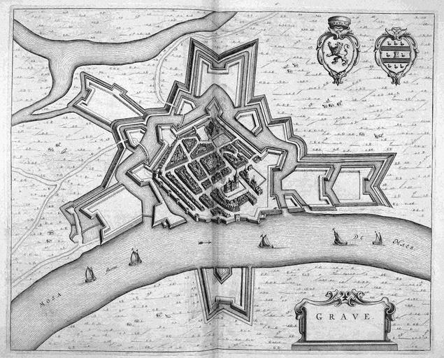
| Keywords: Atlas Beudeker-C9E10 034 09C-GRAVE.jpeg accession number Publisher Creator Joan Blaeu credit line 1649 Tegen het einde van de Tachtigjarige oorlog vatte Joan Blaeu 1596-1673 het plan op om een atlas uit te geven van alle steden en vestingen in de Noordelijke en de Zuidelijke Nederlanden In 1649 publiceerde hij deze atlas in twee delen Hoewel de stad Grave tot het grondgebied van de Republiek hoorde werd deze kaart opgenomen in het tweede deel dat gewijd is aan de steden in de Spaanse Nederlanden At the end of the Eighty Years War Joan Blaeu 1596-1673 developed a plan to publish an atlas with all cities and fortresses in the Northern and Southern Netherlands He published this atlas in two volumes in 1649 Although Grave was part of the Republic this map was included in the second volume which was dedicated to the Spanish Netherlands 42 x 52 5 cm exhibition history British Library Kopergravure Technique copper engraving C9E10 034_09C Information field Related persons Creator Joan_Blaeu Information field Depicted locations Netherlands - Grave object history object type Kaart Map PD-old-100 place of creation Amsterdam place of discovery Source page at the http //resolver kb nl/resolve urn urn gvn KONB01 482 Geheugen van Nederland / Memory of the Netherlands website British Library image Maps C 9 e 10 GRAVE Uploaded with GWToolset Atlas Beudeker-C9E10 034_09C-GRAVE http //resolver kb nl/resolve urn urn gvn KONB01 034_09C size large Atlas Beudeker Grave Netherlands | ||||