MAKE A MEME
View Large Image
| View Original: | Atlas_Beudeker-C9E10_015_05B-RAVESTEIN;_HELMONT.jpeg (3669x5500) | |||
| Download: | Original | Medium | Small | Thumb |
| Courtesy of: | commons.wikimedia.org | More Like This | ||
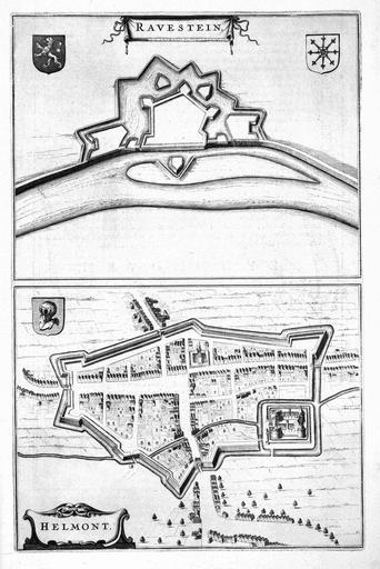
| Keywords: Atlas Beudeker-C9E10 015 05B-RAVESTEIN; HELMONT.jpeg accession number Publisher Creator Joan Blaeu credit line 1649 Op dit kaartblad zien we een plattegrond van het fort Ravestein en de stad Helmond In tegenstelling tot de plattegrond van Helmond waarop de kartograaf ook aandacht heeft voor het stratenpatroon ontbreekt die topografie nadrukkelijk bij de afbeelding van Ravestein Hier zien we alleen de omtrekken van de verdedigingswerken Deze kaart werd in 1649 opgenomen in het stedenboek van Joan Blaeu 1596-1673 This map shows the city plans of the fortress Ravestein and the city of Helmond Although the street pattern has been represented in the city plan of Helmond this aspect of topography lacks in the plan of Ravestein Only the outlines of the military works are visible This map was included in the Town Books of the Netherlands by Joan Blaeu 1596-1673 in 1649 19 x 25 cm 2 x exhibition history British Library Kopergravure Technique copper engraving C9E10 015_05B Information field Related persons Creator Joan_Blaeu Information field Depicted locations Netherlands - Ravestein - Helmond object history object type Kaart Map PD-old-100 place of creation Amsterdam place of discovery Source page at the http //resolver kb nl/resolve urn urn gvn KONB01 463 Geheugen van Nederland / Memory of the Netherlands website British Library image Maps C 9 e 10 RAVESTEIN; HELMONT Uploaded with GWToolset Atlas Beudeker-C9E10 015_05B-RAVESTEIN; HELMONT http //resolver kb nl/resolve urn urn gvn KONB01 015_05B size large Atlas Beudeker | ||||