MAKE A MEME
View Large Image
| View Original: | Arad_Josephinische_Landesaufnahme_pg24-27.jpg (8570x5720) | |||
| Download: | Original | Medium | Small | Thumb |
| Courtesy of: | commons.wikimedia.org | More Like This | ||
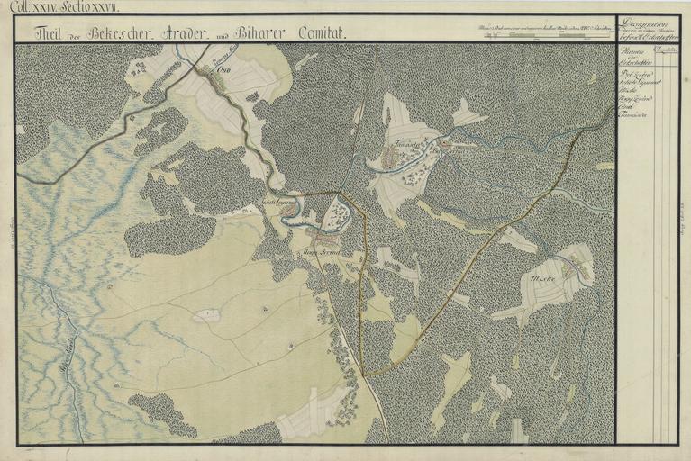
| Keywords: Arad Josephinische Landesaufnahme pg24-27.jpg wikitable style margin 1em auto 1em auto width 80 Name shown on the map<br>Nume din hartă Administrative unit<br>Unitate administrativă Romanian name<br>Numele românesc Hungarian name<br>Numele unguresc German name<br>Numele german Country today<br>Ţara de astăzi - Bel Zerénd Bihar<br>Bihar vármegye<br>Comitatul Bihor<br>Komitat Bihar Zerindu Mic Belzerind Luntreni Bélzerénd Bélzerind Bélselénd Kiszerind Zerind Romania - Fekete Gyarmat Arad<br>Arad vármegye<br>Comitatul Arad<br>Komitat Arad Iermata Neagră Feketegyarmat Gyarmat Romania - Miske Arad Mişca Tőzmiske Miske Romania - Nagy Zerénd Arad Zerind Zerindul Mare Nagyzerénd Nagyzerind Nagyselénd Zerind Romania - Ond Bihar Ant Ant Romania - Tamásda Bihar Tămaşda Tamáshida Tamásd Romania - Kingdom of Hungary 1782-85 Josephinische Landesaufnahme pg 24-27 <br>Counties shown on the map <br>1 Bihar County<br>2 Bekeser County<br>3 Arad County Harta Iosefină a Regatului Ungariei 1782-85 Josephinische Landesaufnahme pg 24-27 <br>Comitate prezentate pe hartă <br>1 Comitatul Bihor<br>2 Comitatul Bichiş<br>3 Comitatul Arad Österreichisches Staatsarchiv Kriegsarchiv Historische Militärkarte der österreichisch-ungarischen Monarchie 1782-1785 PD-old-100 Clickable Map of the Arad County AradCountyJosephinischeLandesaufnahme Josephinische Landaufnahme Old maps of Békés County | ||||