MAKE A MEME
View Large Image
| View Original: | Angles,_Saxons,_Jutes_in_Britain_year_600.jpg (1126x810) | |||
| Download: | Original | Medium | Small | Thumb |
| Courtesy of: | commons.wikimedia.org | More Like This | ||
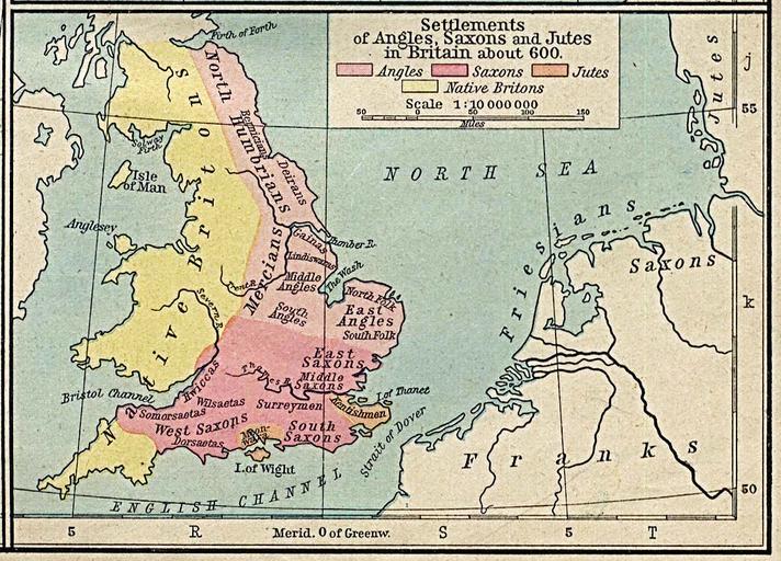
| Keywords: Angles, Saxons, Jutes in Britain year 600.jpg Original Sumario Distribución de los anglos rosa los sajones rojo jutos naranja y británico nativos amarillo en la isla de Gran Bretaña en el año 600 es Mapa de Gran Bretaña en el año 600 con la correspondiente distribución de los pueblos Anglos Sajones y Jutos Autorización del autor Unless marked otherwise the maps scanned by the University of Texas Libraries are in the public domain The map images are not copyrighted and no permission is needed to copy them You may download them and use them as you wish We do appreciate hearing from you about your use of these materials and we also appreciate you giving this site credit Appropriate credit for public domain materials would be Courtesy of the University of Texas Libraries The University of Texas at Austin For more information see The PCL Map Collection Frequently Asked Questions page at http //www lib utexas edu/maps/faq html or feel free to contact me __ Becky Schaefer Digital Library Services Division University of Texas Libraries rschaefer austin utexas edu Licensing updated PD-old Maps showing history by William R Shepherd Maps of Anglo-Saxon England Maps of the history of Scotland | ||||