MAKE A MEME
View Large Image

| View Original: | An_Exact_Plan_and_Section_of_Old_Sarum.jpg (2000x1690) | |||
| Download: | Original | Medium | Small | Thumb |
| Courtesy of: | commons.wikimedia.org | More Like This | ||
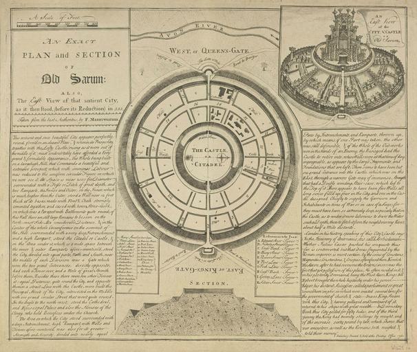
| Keywords: An Exact Plan and Section of Old Sarum.jpg woodcut Oriented with West at the top of the page and North on the right <br><u>Text</u> cols This antient and once beautiful City appears perfectly round form'd on an elegant Plan when its Prosperity together with the Lofty Castle rising as it were out of the middle of it must undoubtedly have afforded a Very grand formidable Appearance the Whole being built on a large high Hill that Commands a beautiful and extensive prospect which with immense Labour was reduced to the uniform circular Figure in which we now see it its Space is near 2000 feet Diameter surrounded with a Fosse or Ditch of great depth and two Ramparts the Inner and the Outer; on the Inner which is much higher then the Outer stood a Wall near 12 feet thick at its basis made with Flint Chalk strongly cemented together and cased with hewn Stone-work on which was a Parapet with Battlements quite round; of this Wall there are still large Remains to be seen on the North-west Side At a considerable Distance in the Center of the whole Circumference on the summit of the Hill surrounded with a very deep Intrenchment and a high Rampart stood the Citadel or Castle in the Area under it which is a wide space between the inner outer Ramparts afore-mention'd stood the City divided into equal parts North and South near the middle of each Division was a Gate which were the two grand Enterances directly opposite had each a Tower over and a Mole of great Strength before them Besides these there were ten other Towers at equal Distances quite round the City and opposite them in a strait Line with the Castle were built the Principal Streets of the City intersected in the Middle with one grand circular Street that went quite round In the Angle to the north-west stood the Cathedral and Episcopal Palace and also the Houses of the Clergy who held Benefices under the Church <br><br>The Area on which the City stood surrounded with a deep Intrenchment high Rampart with Walls and Towers afore-mentioned was also for its greater Strength and Security divided into nearly equal Parts by Intrenchments and Ramparts thrown up by which means if one Part was taken the other was still defensible if the Whole of the Out-works were in the Hands of an Enemy the Besieged had the Castle to retire into whose Walls were at that time of day impregnable as appears by the large Fragments and Foundations that are left There seems to have been but one grand Entrance into the Castle which was on the East through a narrow Gate-way of immense Strength that had a Double winding Stair-case which led to the Top of it There appears to have been five Wells all long since fill'd up four in the City and one in the Castle designed Chiefly to supply the Garrison and Inhabitants in time of War or in case of a Siege; for they must have been so extremely deep especialy that in the Castle as to render it more laborious to draw the Water such a Depth then to fetch it from the neighbouring River about half a Mile distant <br><br>Camden in his History speaking of this City Castle says In the Itinerary of Antoninus it is call'd Sorbiodunum Whether Julius C√¶sar pushed his conquests thus far is controverted but that it was frequented by the Roman emperors is most certain by the coins of Constans Magnentius Constantine Crispus often found there Kenrick the Saxon after he had overcome the Britons in 553 was the first that got possession of this place He often resided in it in his posterity it remained being the West Saxon Kings till Egbert brough the whole heptarchy under his power Edgar his distant Successor called a parliament or great council here in 960 in which were enacted several laws for the government of church state In 1003 King Swain took this City having pillaged and burnt part of it return'd to his ships with great wealth In Doomsday Book this City gelded for fifty hides and of the third penny the King had twenty shillings by weight and of the increase sixty pound by tale; which shews that our ancestors as well as the Romans both weighed told their money <br><br>Salisbury Printed Sold at the Printing Office 1761 <u>Legend</u> 1 Mary-Street<br>2 Peters-Lane<br>3 Edm<sup><small>d</small></sup>-Street<br>4 Nich<sup><small>s</small></sup>-Street<br>5 Marpal-Str<sup><small>t</small></sup><br>6 Nathan-Str<sup><small>t</small></sup><br>7 Charam-Str<sup><small>t</small></sup><br>8 Fish-Row<br>9 Gardner's-Row<br>10 Hurd-Street<br>11 Bury-Street<br>12 Bakers-Row<br>13 Queen-Street<br>14 High-Church-Lane<br>15 Queengate-Row<br>16 Merton-Street 17 Port-Lane<br>18 Bearing-Street<br>19 Peak-Lane<br>20 Butter-Street<br>21 Groom-Lane<br>22 Marcel-Walk<br>23 Silver Street<br>24 Kingsbury Street<br><small>aaa</small> Palaces for the Clergy<br><small>e</small> Meadows <u>References to the Plan </u><br>A Edmund-Street† Tower<br>B Nicholas-Street† Tower<br>C Cross-Bank† Tower<br>D Bury-Street† Tower<br>E Queen-Street† Tower<br>F Port-Lane† Tower<br>G Peak-Lane† Tower<br>H Cross-Bank† Tower<br>I Groom-Lane† Tower<br>K Silver-Street† Tower 1761 An Exact Plan and Section of Old Sarum also The East View of that antient City as it then stood before its Reduction in 553 43 √ó 51 4 cm printed at Salisbury by the 'Printing Office' F Merryweather other versions Old Sarum png PD-old-100-1923 Uploaded with UploadWizard Old Sarum Fictional landscapes Street maps of England | ||||