MAKE A MEME
View Large Image
| View Original: | AMH-8572-NA_Map_of_the_island_of_Tamarica.jpg (2400x1899) | |||
| Download: | Original | Medium | Small | Thumb |
| Courtesy of: | commons.wikimedia.org | More Like This | ||
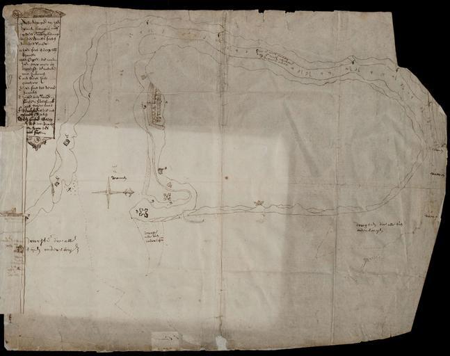
| Keywords: AMH-8572-NA Map of the island of Tamarica.jpg Artwork nl Kaart van het eiland Tamarica nl Kaart van het eiland Tamarica Titel in Catalogus Leupe NA Afbeeldinge van het Eyland Tamagua mitsgaders d'affteyckeninge van des vyandts forten mitsgaders d'onse Affbeeldingh van het Eylandt Tamagua metsgaders d'affteyckening van des vijandts forten mitsgaders d'onse De kaart geeft de positie van de Nederlandse forten en die van de Portugezen aan en Map of the island of Tamarica Title in the Leupe Catalogue NA Afbeeldinge van het Eyland Tamagua mitsgaders d'affteyckeninge van des vyandts forten mitsgaders d'onse Affbeeldingh van het Eylandt Tamagua metsgaders d'affteyckening van des vijandts forten mitsgaders d'onse The chart indicates the location of the Dutch forts and those of the Portuguese Atlas of Mutual Heritage na http //www atlasofmutualheritage nl/en/object/ id 8572 Source at the Atlas of Mutual Heritage - http //www gahetna nl/collectie/archief/inventaris/index/eadid/4 VEL/inventarisnr/701/level/file Source at the Nationaal Archief en Subjects chart / map / plan banderole / cartouche / ornamentation banderole / cartouche / ornamentation building fortification house compass / dial nl Onderwerpen plattegrond / kaart banderol / cartouche / versiering banderol / cartouche / versiering gebouw vesting huis / woonhuis kompas / windroos en Post this image is related to a WIC trading post called http //www atlasofmutualheritage nl/en/post/ id 1029 Itamaracà eiland Inscription Affbeeldingh van het Eylandt Tamagua metsgaders d'affteyckening van des vijandts forten mitsgaders d'onse nl circa 1630 nl Anoniem / Anonymous landmeter / kaartenmaker en Anoniem / Anonymous land surveyor / mapmaker Institution Nationaal Archief nl pen op papier en pen on paper Size cm 39 42 accession number NL-HaNA_4 VEL_701 old number VEL0701 PD-Art-100 Maps of the West-Indische Compagnie 1630 | ||||