MAKE A MEME
View Large Image
| View Original: | AMH-8571-NA_Map_of_the_island_of_Tamarica.jpg (2400x1943) | |||
| Download: | Original | Medium | Small | Thumb |
| Courtesy of: | commons.wikimedia.org | More Like This | ||
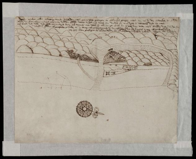
| Keywords: AMH-8571-NA Map of the island of Tamarica.jpg Artwork nl Kaart van het eiland Tamarica nl Kaart van het eiland Tamarica Titel in Catalogus Leupe NA Caerte ofte ontwerp van 't Eylandt Tamaryca gelegen in Brasyl N t O van de STadt Olinda de Fernebock waerin vertoont wert den vyandt syn Casteel en de wercken daerom oock ons fort enz Caerte ofte ontwerp vant teijlandt Tamarijca gelegen in Brasijl De kaart geeft de positie van de Nederlandse forten en die van de Portugezen aan en Map of the island of Tamarica Title in the Leupe Catalogue NA Caerte ofte ontwerp van 't Eylandt Tamaryca gelegen in Brasyl N t O van de STadt Olinda de Fernebock waerin vertoont wert den vyandt syn Casteel en de wercken daerom oock ons fort enz Caerte ofte ontwerp vant teijlandt Tamarijca gelegen in Brasijl The chart shows the location of the Dutch forts and those of the Portuguese Atlas of Mutual Heritage na http //www atlasofmutualheritage nl/en/object/ id 8571 Source at the Atlas of Mutual Heritage - http //www gahetna nl/collectie/archief/inventaris/index/eadid/4 VEL/inventarisnr/700/level/file Source at the Nationaal Archief en Subjects chart / map / plan bird's-eye view / elevation elevation / bird's-eye view compass / dial fortification building house nl Onderwerpen plattegrond / kaart vogelvlucht / opstand opstand / vogelvlucht kompas / windroos vesting gebouw huis / woonhuis en Post this image is related to a WIC trading post called http //www atlasofmutualheritage nl/en/post/ id 1029 Itamaracà eiland Inscription Caerte ofte ontwerp vant teijlandt Tamarijca nl circa 1630 nl Anoniem / Anonymous landmeter / kaartenmaker en Anoniem / Anonymous land surveyor / mapmaker Institution Nationaal Archief nl pen op papier en pen on paper Size cm 33 42 accession number NL-HaNA_4 VEL_700 old number VEL0700 PD-Art-100 Maps of the West-Indische Compagnie 1630 | ||||