MAKE A MEME
View Large Image
| View Original: | AMH-5503-NA_Map_of_Ceylon,_the_Maldives_and_the_coasts_of_Malabar_and_Madure.jpg (1868x2400) | |||
| Download: | Original | Medium | Small | Thumb |
| Courtesy of: | commons.wikimedia.org | More Like This | ||
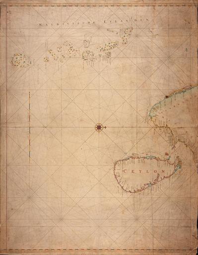
| Keywords: AMH-5503-NA Map of Ceylon, the Maldives and the coasts of Malabar and Madure.jpg Artwork nl Kaart van Ceilon de Maladiven en de kusten van Malabar en Madure nl Titel catalogus Leupe NA Kaart van de Maldivische Eylanden de Kust van Malabaar Madure en Ceilon Bijzonderheden de kaart is op blauw papier geplakt Notities verso XXX en Title in the Leupe catalogue NA Kaart van de Maldivische Eylanden de Kust van Malabaar Madure en Ceilon Particulars the map has been pasted on blue paper Notes on reverse XXX Atlas of Mutual Heritage na http //www atlasofmutualheritage nl/en/object/ id 5503 Source at the Atlas of Mutual Heritage - http //www gahetna nl/collectie/archief/inventaris/index/eadid/4 VEL/inventarisnr/234/level/file Source at the Nationaal Archief en Subjects chart / map / plan nl Onderwerpen plattegrond / kaart en Post this image is related to a VOC trading post called http //www atlasofmutualheritage nl/en/post/ id 355 Cranganur Inscription - nl between 1756 1780 Creator Johannes van Keulen II nl Johannes van Keulen II toegeschreven aan en Johannes van Keulen II assigned to Institution Nationaal Archief nl koperdruk op papier en copperplate printing on paper Size cm 82 5 106 accession number NL-HaNA_4 VEL_234 old number VEL0234 PD-Art-100 Maps of the Dutch East India Company - India Maps of the Dutch East India Company - Sri Lanka | ||||