MAKE A MEME
View Large Image
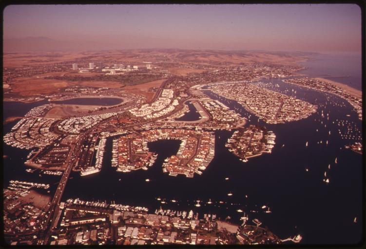
| View Original: | AERIAL_OF_UPPER_NEWPORT_BAY_IN_ORANGE_COUNTY,_SOUTH_OF_LOS_ANGELES_SHOWING_DEVELOPED_AREAS._NEARBY_UNDEVELOPED_AREAS..._-_NARA_-_557422.jpg (3000x2044) | |||
| Download: | Original | Medium | Small | Thumb |
| Courtesy of: | commons.wikimedia.org | More Like This | ||
| Keywords: AERIAL OF UPPER NEWPORT BAY IN ORANGE COUNTY, SOUTH OF LOS ANGELES SHOWING DEVELOPED AREAS. NEARBY UNDEVELOPED AREAS... - NARA - 557422.jpg Scope and content General notes 557422 Local identifier 412-DA-14970 Environmental Protection Agency 12/02/1970 - NARA-Author O'Rear Charles 1941- Photographer 3403717 <br /> Los Angeles Los Angeles county California United States North and Central America inhabited place 4219264 34 05 -118 23 <br /> Still Picture Records Section Special Media Archives Services Division NWCS-S National Archives at College Park 8601 Adelphi Road College Park MD 20740-6001 06/1975 Record group Record Group 412 Records of the Environmental Protection Agency 1944 - 2006 Record group ARC 708 DOCUMERICA The Environmental Protection Agency's Program to Photographically Document Subjects of Environmental Concern compiled 1972 - 1977 Series ARC 542493 File unit File unit ARC Variant control numbers Agency-Assigned Identifier 250/30/014970<br /> NAIL Control Number NWDNS-412-DA-14970 Other versions <gallery> File AERIAL_OF_UPPER_NEWPORT_BAY_IN_ORANGE_COUNTY _SOUTH_OF_LOS_ANGELES_SHOWING_DEVELOPED_AREAS _NEARBY_UNDEVELOPED_AREAS _-_NARA_-_557422 tif tif File AERIAL_OF_UPPER_NEWPORT_BAY_IN_ORANGE_COUNTY _SOUTH_OF_LOS_ANGELES_SHOWING_DEVELOPED_AREAS _NEARBY_UNDEVELOPED_AREAS _-_NARA_-_557422 jpg jpg </gallery> NARA-cooperation PD-USGov Aerial photographs of Orange County California Upper Newport Bay | ||||