MAKE A MEME
View Large Image

| View Original: | 25_Years_Since_Loma_Prieta_Earthquake.jpg (3072x2048) | |||
| Download: | Original | Medium | Small | Thumb |
| Courtesy of: | www.flickr.com | More Like This | ||
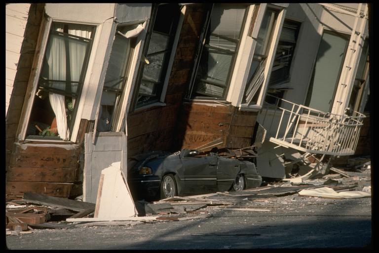
| Keywords: earthquake usgs san francisco sanfrancisco loma prieta lomaprieta anniversary natural hazards naturalhazards preparedness quake california architecture column outdoor Today marks the 25th anniversary of a devastating earthquake that struck the San Francisco area. On October 17, 1989, at 5:04:15 p.m. (PDT), a magnitude 6.9 earthquake severely shook the San Francisco and Monterey Bay regions. The epicenter was located near Loma Prieta peak in the Santa Cruz Mountains. The 1989 Loma Prieta earthquake ended decades of tranquility in the San Francisco Bay region. It was a wakeup call to prepare for the potentially even more devastating shocks that are inevitable in the future. Since 1989, the work of the U.S. Geological Survey and other organizations has improved understanding of the seismic threat in the Bay region, promoted awareness of earthquake hazards, and contributed to more effective strategies to reduce earthquake losses. These efforts will help reduce the impact of future large quakes in the San Francisco Bay region. In this photo: An automobile lies crushed under the third story of this apartment building in the Marina District. The ground levels are no longer visible because of structural failure and sinking due to liquefaction. [J.K. Nakata, USGS] Learn more about what happened, many more photos and maps at bit.ly/LomaPrieta Today marks the 25th anniversary of a devastating earthquake that struck the San Francisco area. On October 17, 1989, at 5:04:15 p.m. (PDT), a magnitude 6.9 earthquake severely shook the San Francisco and Monterey Bay regions. The epicenter was located near Loma Prieta peak in the Santa Cruz Mountains. The 1989 Loma Prieta earthquake ended decades of tranquility in the San Francisco Bay region. It was a wakeup call to prepare for the potentially even more devastating shocks that are inevitable in the future. Since 1989, the work of the U.S. Geological Survey and other organizations has improved understanding of the seismic threat in the Bay region, promoted awareness of earthquake hazards, and contributed to more effective strategies to reduce earthquake losses. These efforts will help reduce the impact of future large quakes in the San Francisco Bay region. In this photo: An automobile lies crushed under the third story of this apartment building in the Marina District. The ground levels are no longer visible because of structural failure and sinking due to liquefaction. [J.K. Nakata, USGS] Learn more about what happened, many more photos and maps at bit.ly/LomaPrieta | ||||