MAKE A MEME
View Large Image
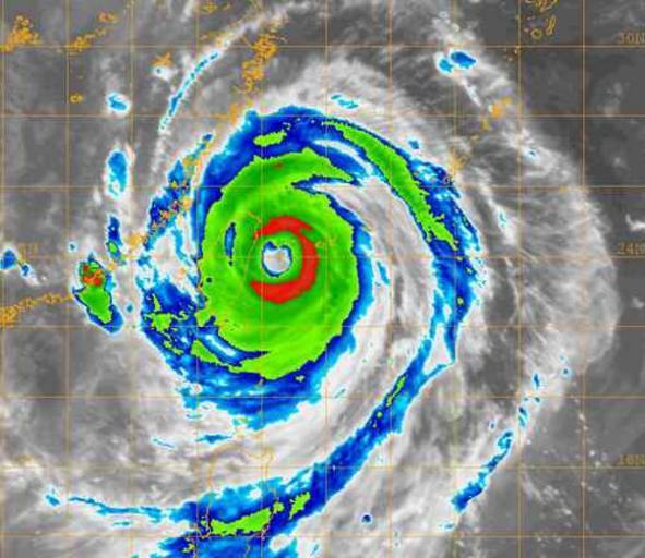
| View Original: | 20050831.1155.goes9.x.ir1km.13WTALIM.105kts-938mb-233N-1239E.jpg (499x432) | |||
| Download: | Original | Medium | Small | Thumb |
| Courtesy of: | commons.wikimedia.org | More Like This | ||
| Keywords: 20050831.1155.goes9.x.ir1km.13WTALIM.105kts-938mb-233N-1239E.jpg http //www nrlmry navy mil/ ńŠÄÕ ŗµĄĘĶ╗ŹńĀöń®ČÕ»”ķ®ŚÕ«żµÅÉõŠøńÜäĶĪøµś¤ķø▓Õ ¢Ń éµĀ╣µōÜÕŠĘµ▓āÕżÅÕģŗÕłåµ×ɵ│Ģµ│░Õł®µŁżµÖéńÜäTµīćµĢĖńé║6 0’╝īńøĖńĢȵ¢╝õĖ ÕłåķÉśÕ╣│Õ ćķó©ÕŖøµ»ÅÕ░ŵÖé115µĄĘµĄ¼µł¢210Õģ¼ķćī’╝īõĖŁÕ┐āµ õĮĵ░ŻÕŻōń┤ä927ńÖŠÕĖĢµ¢»ÕŹĪŃ é Satellite cloud picture of Typhoon Talim The average wind speed was en convert 115 kn km/h mph the central lowest barometric pressure was approximately 92700 Pa psi 08/31/05 0600Z 13W TALIM 08/31/05 1155Z GOES-9 IR http //www nrlmry navy mil/tc_pages/tc_home html NRL Naval Research Laboratory Monterey Marine Meteorology Division Tropical Cyclone Page 2005-10-31 http //www nrlmry navy mil/sat_products html NRL Naval Research Laboratory Monterey Marine Meteorology Division Public Domain - Sailor or employee of the U S Navy PD-USGov-Military-Navy from zhwp ÕłĀķÖżĶ»źÕøŠÕāÅńÜäµē µ ēõ┐«Ķ«óńēłµ ¼ ÕĮōÕēŹ 15 28 2005Õ╣┤9µ ł1µŚź Simonlo 500x500 35942ÕŁŚĶŖé ńŠÄÕ ŗµĄĘĶ╗ŹńĀöń®ČÕ»”ķ®ŚÕ«żµÅÉõŠøńÜäĶĪøµś¤ķø▓Õ ¢Ń é Typhoon Talim 2005 NRL images of tropical cyclones | ||||