MAKE A MEME
View Large Image
| View Original: | 1900_National_Publishing_Railroad_Map_of_Connecticut,_Massachusetts,_and_Rhode_Island_-_Geographicus_-_MACTRI-nationalpublishing-1900.jpg (6000x5632) | |||
| Download: | Original | Medium | Small | Thumb |
| Courtesy of: | commons.wikimedia.org | More Like This | ||
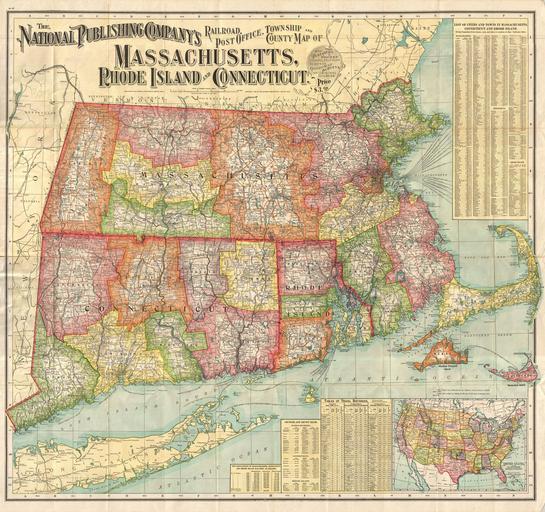
| Keywords: 1900 National Publishing Railroad Map of Connecticut, Massachusetts, and Rhode Island - Geographicus - MACTRI-nationalpublishing-1900.jpg A large and impressive relic of the great age of American Railroads This dramatic map issued by the National Publishing Company in 1900 covers the states of Massachusetts Connecticut and Rhode Island with adjacent parts of Long Island Maine Vermont New Hampshire and New York The map is color coded to show county and township configurations but its true and evident purpose is to help travelers navigate the confusing network of train trolley and coach lines that operated throughout the region This map shows major trunk lines heading to Hartford Springfield Providence and Boston with numerous branch lines most run my small companies serving smaller towns and cities When this map was printed the Age of Rail was well developed in New England with all but 20 of the region's towns and cities connected by one of the many private rail lines This particular example of this well known map is issued in pocket map format and is much rarer than the more common though identical wall map issued at the same time 1900 dated Size in 38 35 object history credit line accession number MACTRI-nationalpublishing-1900 Geographicus-source PD-art Old maps of Massachusetts Old maps of Rhode Island Old maps of Connecticut 1900 maps Rail transport maps of Massachusetts Rail transport maps of Connecticut Rail transport maps of Rhode Island | ||||