MAKE A MEME
View Large Image
| View Original: | 1886_Depot_de_la_Guerre_Pocket_Map_of_Paris_and_Environs_-_Geographicus_-_Paris-depotdeguerre-1886.jpg (6000x4118) | |||
| Download: | Original | Medium | Small | Thumb |
| Courtesy of: | commons.wikimedia.org | More Like This | ||
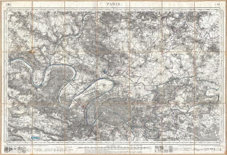
| Keywords: 1886 Depot de la Guerre Pocket Map of Paris and Environs - Geographicus - Paris-depotdeguerre-1886.jpg An exceptionally attractive military plan of Paris dating to 1886 Issued by the French mapping bureau the Depot de la Guerre this extremely detailed chart covers the vicinity of Paris from the Foret de Carnelle in the north to Versailles in the south and from Meulan in the west to Chessy in the east Paris proper appears in the at the bottom center Shows the Enbastillement of Paris in the form of the city walls and the various ring forts The detail throughout is nothing short of extraordinary with garden paths and individual buildings identified This map was published in 1886 one year before the Depot de la Guerre was disbanded and is therefore one of the last such maps produced by the Depot 1886 dated Size in 34 5 23 5 object history credit line accession number Paris-depotdeguerre-1886 Geographicus-source PD-art Maps of Paris in the 19th century 19th-century maps of Paris 1886 maps Paris in the 1880s | ||||