MAKE A MEME
View Large Image

| View Original: | 1874_Ludlow_and_Custer_Map_of_The_Black_Hills_-_Geographicus_-_BlackHills-custer-1874.jpg (4000x4764) | |||
| Download: | Original | Medium | Small | Thumb |
| Courtesy of: | commons.wikimedia.org | More Like This | ||
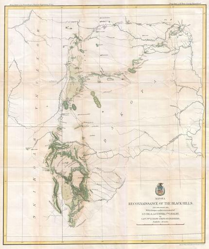
| Keywords: 1874 Ludlow and Custer Map of The Black Hills - Geographicus - BlackHills-custer-1874.jpg George Armstrong Custer and William Ludlow's seminal 1874 map of the Black Hills Dakota Territory covering from the Missouri to the Powder River and from the 47th to the 43rd parallel In 1874 one thousand cavalrymen under the command of Lt Col George Armstrong Custer moved into the Black Hills region of Dakota Territory Though officially American Indian territory according to the 1868 Treaty of Laramie rumors had been circulating since the early 19th century that this region harbored rich deposits of gold Custer and his men were sent to investigate With Custer was William Ludlow an officer of the Army Corps of Engineers inheritor of the legacy left by the Topographical Engineers whose commission was to explore and survey the region identifying in the process if the rumored gold did indeed exist Ludlow and Custer traveled west from Fort Lincoln on the Missouri River near Bismarck to the Powder River thence north and South into the Black Hills Their path many camp sites and survey triangulation points are documented throughout Ludlow compounded his work by attaching it to pre-existing exploratory survey work performed by Reynolds in 1859-60 Warren in 1857 and Sully in 1864 and to the Northern Pacific Railroad Surveys performed in 1871 and 1872 all of which are noted As a whole this map is full of fascinating detail which lead map historian C I Wheat to call it a most interesting map Throughout Ludlow offers commentary on the territory such as High hills heavily timbered Water and grass abundant grass and water good bad lands and soil and loose dry clay In addition to his scientific and geological notations Ludlow also offers some interesting historical commentary such identifying the site where they killed the Rees and where the sick man was killed these both possibly reference events on the 1871 Pacific Railroad Survey wherein friendly Indian guides of the Rees tribe were killed by raiding Sioux Ultimately Custer and his men did find gold in the Black Hills leading to the 1876 Black Hills Gold Rush Completely disregarding the Treaty of Laramie gold hungry settlers rushed into the region coming into immediate conflict with the warlike Sioux Custer's foolish attack on the Sioux encampment and the subsequent massacre at Little Big Horn were a direct result of this conflict Ultimately the Black Hills Gold discovery turned out to be one of the greatest gold strikes in history producing 10 of the world's gold supply for the next 125 years Published along with two other maps in Ludlow's 1874 Report of a Reconnaissance of the Black Hills 1874 dated Size in 21 5 25 5 object history credit line accession number BlackHills-custer-1874 Ludlow W <i>Report of a Reconnaissance of the Black Hills</i> 1874 Geographicus-source PD-art Old maps of South Dakota 1874 maps Black Hills William Ludlow | ||||