MAKE A MEME
View Large Image
| View Original: | 1874_Beers_Map_of_Florida,_Georgia,_North_Carolina_and_South_Carolina_-_Geographicus_-_NCSCGAFL-beers-1874.jpg (3260x4000) | |||
| Download: | Original | Medium | Small | Thumb |
| Courtesy of: | commons.wikimedia.org | More Like This | ||
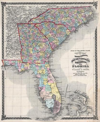
| Keywords: 1874 Beers Map of Florida, Georgia, North Carolina and South Carolina - Geographicus - NCSCGAFL-beers-1874.jpg An attractive hand colored 1874 map of the southeastern part of the United States by Warner and Beers Includes the states of North Carolina South Carolina Georgia and Florida Also includes part of the Bahamas Detailed to the county level with roads railroads towns forts and geographical features noted Surrounded by decorative border Published in by Warner and Beers in 1874 as plate no 71 in H H Lloyd ™s Atlas of the United States 1874 undated Size in 14 5 18 object history credit line accession number NCSCGAFL-beers-1874 H H Lloyd and Company's <i>Atlas of the United States</i> 1874 edition Geographicus-source PD-art Old maps of Florida Old maps of South Carolina Old maps of North Carolina Old maps of Georgia U S state 1874 maps | ||||