MAKE A MEME
View Large Image

| View Original: | 1873_Beers_Map_of_the_Towns_of_Hempstead,_Rockville_and_Pearsalls,_Long_Island,_New_York_-_Geographicus_-_HempsteadRockville-beers-1873.jpg (4000x5444) | |||
| Download: | Original | Medium | Small | Thumb |
| Courtesy of: | commons.wikimedia.org | More Like This | ||
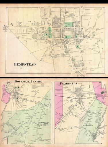
| Keywords: 1873 Beers Map of the Towns of Hempstead, Rockville and Pearsalls, Long Island, New York - Geographicus - HempsteadRockville-beers-1873.jpg A scarce example of Fredrick W Beers ™ map of the communities of Hempstead Rockville and Persalls Long Island Published in 1873 Maps printed on both recto and verso Hempstead side depicts the town of Hempstead from Jackson Street south to Jerusalem Avenue Details St Georges Cemetery and the Old Town Burying Ground Verso features maps of Rockville Center and Christian hook as well as Pearsalls and East Rockaway Detailed to the level of individual properties and buildings with land owners noted This is probably the finest atlas map these Long Island communities to appear in the 19th century Prepared by Beers Comstock Cline out of their office at 36 Vesey Street New York City for inclusion in the first published atlas of Long Island the 1873 issue of Atlas of Long Island New York 1873 undated Size in 22 15 object history credit line accession number HempsteadRockville-beers-1873 <i>Atlas of Long Island New York From Recent Actual Surveys and Records Under the Superintendence of F W Beers </i> 1873 First Edition Geographicus-source PD-art File Rockville Centre Hempstead Town Queens Co NYPL1527305 tiff Beers maps of Long Island published in 1873 Town of Hempstead New York Hempstead Village New York Lynbrook New York Rockville Centre New York | ||||