MAKE A MEME
View Large Image
| View Original: | 1873_Beers_Map_of_the_Flushing_Railroad,_Long_Island,_Queens,_New_York_-_Geographicus_-_FlushingRailroad-beers-1873.jpg (3434x4000) | |||
| Download: | Original | Medium | Small | Thumb |
| Courtesy of: | commons.wikimedia.org | More Like This | ||
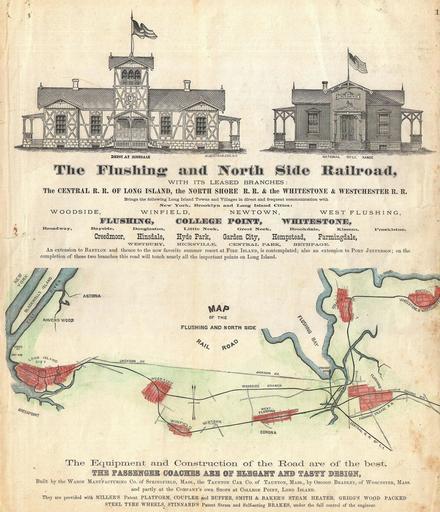
| Keywords: 1873 Beers Map of the Flushing Railroad, Long Island, Queens, New York - Geographicus - FlushingRailroad-beers-1873.jpg A scarce example of Fredrick W Beers ™ map of the Flushing and North Side Railroads Queens Long Island New York Published in 1873 Covers from Long Island City Queens eastward as far as Whitestone College Point and Flushing Details the course of the railroad with notes on major stops Engravings of the Depot at Hinsdale and the National Rifle Range on top of map Advertisement at the bottom of the map refers to the luxury and elegance of the trains and their design Prepared by Beers Comstock Cline out of their office at 36 Vesey Street New York City for inclusion in the first published atlas of Long Island the 1873 issue of Atlas of Long Island New York 1873 undated Size in 12 14 object history credit line accession number FlushingRailroad-beers-1873 <i>Atlas of Long Island New York From Recent Actual Surveys and Records Under the Superintendence of F W Beers </i> 1873 First Edition Geographicus-source PD-art Beers maps of Long Island published in 1873 Old railroad maps of New York Flushing Queens Long Island Rail Road maps Old maps of Queens New York City | ||||