MAKE A MEME
View Large Image
| View Original: | 1873_Beers_Map_of_College_Point,_Queens,_New_York_City_(set_of_2_maps)_-_Geographicus_-_CollegePoint-beers-1873.jpg (4000x5358) | |||
| Download: | Original | Medium | Small | Thumb |
| Courtesy of: | commons.wikimedia.org | More Like This | ||
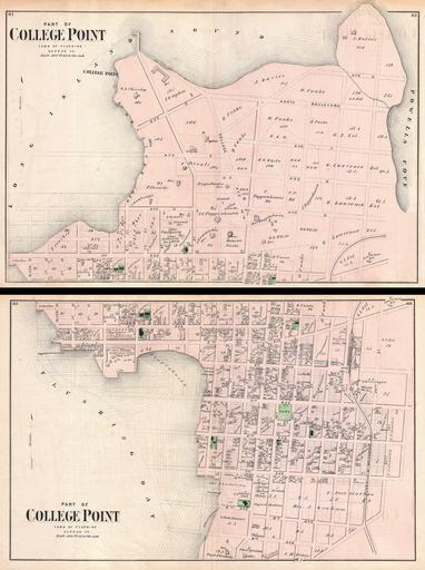
| Keywords: 1873 Beers Map of College Point, Queens, New York City (set of 2 maps) - Geographicus - CollegePoint-beers-1873.jpg A scarce example of Fredrick W Beers ™ two map set of College Point Queens New York Published in 1873 Bottom sheet covers roughly from what was then 9th Avenue northward as far as what was then 2nd avenue Top sheet continues from 2nd avenue to College Point and the Long Island Sound Bounded on the east by Flushing Bay and on the west by Powells Cove Proposed landfills in the Long Island Sound and Flushing bay ghosted in Detailed to the level of individual buildings and properties with land holders noted This is probably the finest atlas map of College Point Queens to appear in the 19th century Prepared by Beers Comstock Cline out of their office at 36 Vesey Street New York City for inclusion in the first published atlas of Long Island the 1873 issue of Atlas of Long Island New York 1873 undated Size in 21 5 29 5 object history credit line accession number CollegePoint-beers-1873 <i>Atlas of Long Island New York From Recent Actual Surveys and Records Under the Superintendence of F W Beers </i> 1873 First Edition Geographicus-source PD-art Beers maps of Long Island published in 1873 College Point Queens | ||||
_-_Geographicus_-_CollegePoint-beers-1873.jpg)