MAKE A MEME
View Large Image
| View Original: | 1871_U.S._Coast_Survey_Map_or_Chart_of_Edgartown_Harbor,_Martha's_Vineyard,_Massachusetts_-_Geographicus_-_Edgartown-uscs-1871.jpg (3086x4000) | |||
| Download: | Original | Medium | Small | Thumb |
| Courtesy of: | commons.wikimedia.org | More Like This | ||
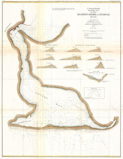
| Keywords: 1871 U.S. Coast Survey Map or Chart of Edgartown Harbor, Martha's Vineyard, Massachusetts - Geographicus - Edgartown-uscs-1871.jpg A very rare 1872 U S Coast Survey Map of Edgartown and Cotamy Bay on Martha's Vineyard Marthas Vineyard Massachusetts Depicts from Edgartown south to Mattakeesett Bay and east to the Opening of 1846 Offers a countless depth soundings throughout as sell as 10 shore sectionals An extremely uncommon find The topography for this map was prepared by H L Whiting The Hydrography is the work of Henry Mitchell See biography below for H Mitchell son of William Mitchell and H I Marindin All work on this chart was completed by the Coast Survey under the direction of Benjamin Pierce Superintendent of the Survey 1871 dated Size in 22 29 object history credit line accession number Edgartown-uscs-1871 <i>Report of the Superintendant of the U S Coast Survey </i> 1872 edition Geographicus-source PD-art United States Coast Survey maps Old maps of Massachusetts Maps of Martha's Vineyard 1871 maps Edgartown Massachusetts | ||||