MAKE A MEME
View Large Image
| View Original: | 1868_Vaux_and_Olmstead_Map_of_Fort_Greene_Park,_Brooklyn,_New_York_-_Geographicus_-_FortGreenPark-bishop-1868.jpg (3000x2348) | |||
| Download: | Original | Medium | Small | Thumb |
| Courtesy of: | commons.wikimedia.org | More Like This | ||
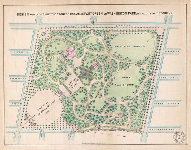
| Keywords: 1868 Vaux and Olmstead Map of Fort Greene Park, Brooklyn, New York - Geographicus - FortGreenPark-bishop-1868.jpg A rare 1868 example Vaux Olmstead's map of Washington Park or as it is now known Fort Greene Park Brooklyn Fort Greene Park is considered to be Brooklyn ™s first park Depicts the park as a whole and includes pathways lakes buildings individual trees rocks and elevation measurements The streets and avenues surrounding the park are also noted The layout of Fort Greene Park shown here reflects Vaux and Olmstead ™s 1864 redesign Like their most famous works Central Park and Prospect Park Vaux and Olmstead were meticulous in their design of the park with every tree pond and bench planned Olmstead wrote Every foot of the parks surface every tree and bush as well as every arch roadway and walk and been placed where it is for a purpose Today because of Vaux and Olmstead ™s efforts the citizens of Fort Greene have the privilege of enjoying what is without question one of the finest examples of a planned urban public recreation area in New York City 1868 dated Size in 11 9 object history credit line accession number FortGreenPark-bishop-1868 Bishop William <i>Manual of the Common Council of the City of Brooklyn 1864</i> 1864 Geographicus-source PD-art Old maps of Brooklyn New York City 1868 maps Brooklyn | ||||