MAKE A MEME
View Large Image
| View Original: | 1868_British_Admiralty_Chart_or_Map_of_the_Mediterranean_Sea_(Italy,_Corsica,_Greece,_Tunisia)_-_Geographicus_-_MediterraneanSea-admiralty-1868.jpg (3902x6000) | |||
| Download: | Original | Medium | Small | Thumb |
| Courtesy of: | commons.wikimedia.org | More Like This | ||
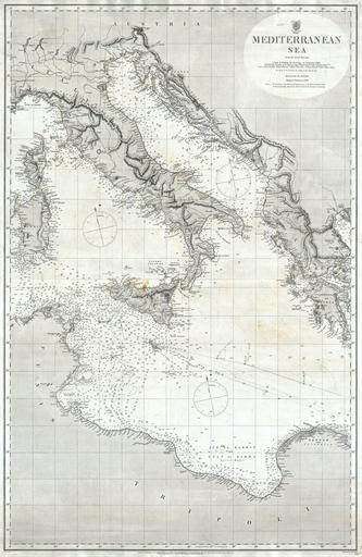
| Keywords: 1868 British Admiralty Chart or Map of the Mediterranean Sea (Italy, Corsica, Greece, Tunisia) - Geographicus - MediterraneanSea-admiralty-1868.jpg A rare and extremely attractive nautical map of the central Mediterranean Sea issued in 1868 by the British Admiralty Covers from Corsica Sardinia and Tunisia eastward past Italy and Sicily to detail Greece and the Adriatic Coast Extends southward as far as the Gulf of Sidra Features both nautical and inland detail noting both topographical features and thousands of depth soundings in fathoms Important ports Island and navigational points are carefully noted Engraved by J C Walker for the British Admiralty under the supervision of Captain Washington R N Originally sold for half a crown by J D Potter of 31 Poultry 11 King Street Tower Hill London Agent for the Admiralty 1868 dated Size in 25 5 39 object history credit line accession number MediterraneanSea-admiralty-1868 Geographicus-source PD-art Old maps of Italy 1868 Sea maps of Italy 1868 J C Walker | ||||
_-_Geographicus_-_MediterraneanSea-admiralty-1868.jpg)