MAKE A MEME
View Large Image
| View Original: | 1865_Spruner_Map_of_the_World_under_the_Assyrian_Empire_-_Geographicus_-_OrbisTerrarumAssyrii-spruner-1865.jpg (3500x2635) | |||
| Download: | Original | Medium | Small | Thumb |
| Courtesy of: | commons.wikimedia.org | More Like This | ||
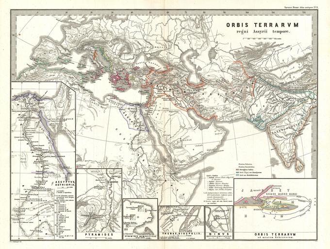
| Keywords: 1865 Spruner Map of the World under the Assyrian Empire - Geographicus - OrbisTerrarumAssyrii-spruner-1865.jpg This is Karl von Spruner ™s 1865 map Orbis Terrarum Regni Assyrii Tempore or The World at the Time of the Assyrian Empire The map features six inserts from left to right Egypt and Ethiopia the Pyramids The Pyramids at Memphis Gaza Thebes Nineveh with particular focus on the capital and the world as known to the Hebrew peoples Map focuses on modern day Egypt Ethiopia Somalia Turkey Saudia Arabia Iraq Iran Afghanistan Pakistan and India Borders outlined in color with a key found in the lower-right quadrant The whole is rendered in finely engraved detail exhibiting throughout the fine craftsmanship of the Perthes firm 1865 undated Size in 16 13 object history credit line accession number OrbisTerrarumAssyrii-spruner-1865 Spruner Karl von <i>Spruner-Menke Atlas Antiquus </i> Gotha Justus Perthes 1865 Geographicus-source PD-old-100 Karl Spruner von Merz Old maps of Europe Old maps of Asia Old maps of Africa Maps of the Assyrian Empire 1865 maps | ||||