MAKE A MEME
View Large Image
| View Original: | 1864_Johnson_Map_of_New_York_-_Geographicus_-_NewYork-johnson-1864.jpg (4500x3126) | |||
| Download: | Original | Medium | Small | Thumb |
| Courtesy of: | commons.wikimedia.org | More Like This | ||
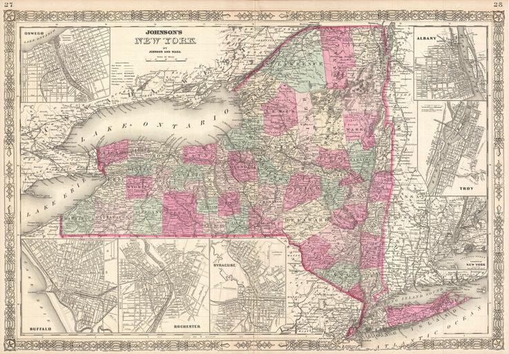
| Keywords: 1864 Johnson Map of New York - Geographicus - NewYork-johnson-1864.jpg This is A J Johnson ™s beautifully hand colored first edition 1864 map of New York This map shows cities topographical features railways ferries and roads with color coding at the county level Insets of Oswego Buffalo Rochester Syracuse Albany Troy and New York City surround the main map Noting that a good number of his subscribers were from New York Johnson made replacing the single page map of New York State he inherited from Colton was one a top priority Johnson introduced this large folio map in the 1861 edition of his atlas and it went through minor annual updates through 1866 when it was again redrawn Published by A J Johnson and Ward as plates 27-28 in the 1864 edition of Johnson ™s New Illustrated Family Atlas This is the first edition of the Johnson ™s Atlas to bear the Johnson Ward imprint and the only edition to identify the firm as the Successors to Johnson and Browning Successors to J H Colton and Company 1864 undated Size in 23 5 17 5 object history credit line accession number s Geographical Statistical and Historic including The Latest Federal Census A Geographical Index and a Chronological History of the Civil War in America</i> first Johnson and Ward 1864 Geographicus-source PD-old-100 Maps by Alvin Jewett Johnson 1864 maps Old maps of New York | ||||