MAKE A MEME
View Large Image
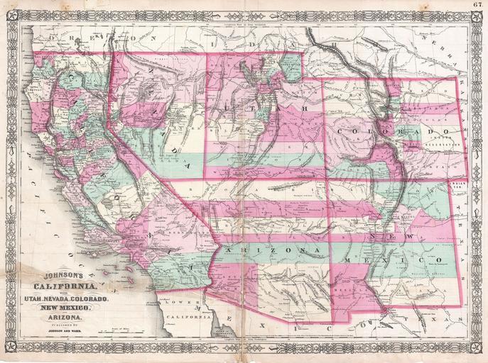
| View Original: | 1864_Johnson_Map_of_California,_Nevada,_Utah,_Arizona,_New_Mexico_and_Colorado_-_Geographicus_-_Southwest2-johnson-1864.jpg (4000x2981) | |||
| Download: | Original | Medium | Small | Thumb |
| Courtesy of: | commons.wikimedia.org | More Like This | ||
| Keywords: 1864 Johnson Map of California, Nevada, Utah, Arizona, New Mexico and Colorado - Geographicus - Southwest2-johnson-1864.jpg This is Johnson and Ward ™s 1864 map of the American southwest Depicts the state of California and the territories of Nevada Utah Colorado Arizona and New Mexico Offers superb detail noting mining districts emigrant trails the Santa Fe Trail the Pony Express Route and several proposed railroads as well as American Indian tribes geological features and local political divisions Features the fretwork border common to Johnson ™s atlas work from 1864 to 1869 This important map went through several different states during its publication period from 1860 to 1870 This critical period in westward expansion saw incredible development and change throughout the region Collecting the various states of this map has become something of a sub-genre for southwestern map aficionados Johnson updated the plates for this map annually and sometimes even issued multiple variants the course of a single year This the 1864 Johnson and Ward version represents a complete re-engraving of the 1862-1863 map Johnson added considerable detail in the mountainous regions of California Nevada and Colorado Arizona and New Mexico appear as independent territories but adhere to the old New Mexico county structure The southern boundary of Nevada with Arizona is set at 37 degrees of Latitude such that Las Vegas which is noted rests firmly within Arizona The Utah-Nevada Border is set at 115 degrees of Longitude roughly one degree further west than it is today Steel plate engraving prepared by A J Johnson for publication as plate no 67 in the 1864 edition of his New Illustrated Atlas ¦ This is the last edition of the Johnson ™s Atlas to bear the Johnson and Ward imprint 1864 dated Size in 23 75 17 25 object history credit line accession number Southwest2-johnson-1864 <i>Johnson's New Illustrated Family Atlas</i> 1864 Johnson Ward Edition Geographicus-source PD-old-100 Maps by Alvin Jewett Johnson 1864 maps Old maps of Arizona Old maps of California Old maps of Nevada Old maps of New Mexico Old maps of Utah | ||||