MAKE A MEME
View Large Image
| View Original: | 1863_Johnson's_Map_of_Colorado,_Dakota,_Idaho,_Nebraska_^_Kansas_-_Geographicus_-_COCANE-j-64.jpg (3500x2824) | |||
| Download: | Original | Medium | Small | Thumb |
| Courtesy of: | commons.wikimedia.org | More Like This | ||
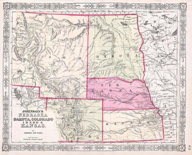
| Keywords: 1863 Johnson's Map of Colorado, Dakota, Idaho, Nebraska ^ Kansas - Geographicus - COCANE-j-64.jpg This is a beautifully hand colored 1863 lithograph map of what today consists of the states of Idaho Wyoming Colorado Montana North Dakota South Dakota Nebraska and Kansas Extends west as far as the Great Salt Lake and east to Lake Superior Large Idaho Territory predates the creation of Wyoming and Montana The newly created territory of Colorado 1861 appears in the lower left Crisscrossed throughout with wagon trails explorer ™s routes railroads and proposed railroads Also offers superb detail regarding the deportment of area American Indian tribes and settlements An important phase of the Johnson Mountain States map series Cartographically this map is based upon the earlier work of J H Colton Page no 63 in the 1863 edition of Johnson ™s Family Atlas 1863 Size in 16 5 13 object history credit line accession number COCANE-j-64 Geographicus-source PD-old-100 Maps by Alvin Jewett Johnson 1863 maps Old maps of Colorado Old maps of North Dakota Old maps of South Dakota Old maps of Idaho Old maps of Kansas Old maps of Nebraska | ||||