MAKE A MEME
View Large Image
| View Original: | 1862_Johnson_Map_of_the_World_on_Hemisphere_Projection_-_Geographicus_-_WorldHemi-johnson-1862.jpg (5000x3073) | |||
| Download: | Original | Medium | Small | Thumb |
| Courtesy of: | commons.wikimedia.org | More Like This | ||
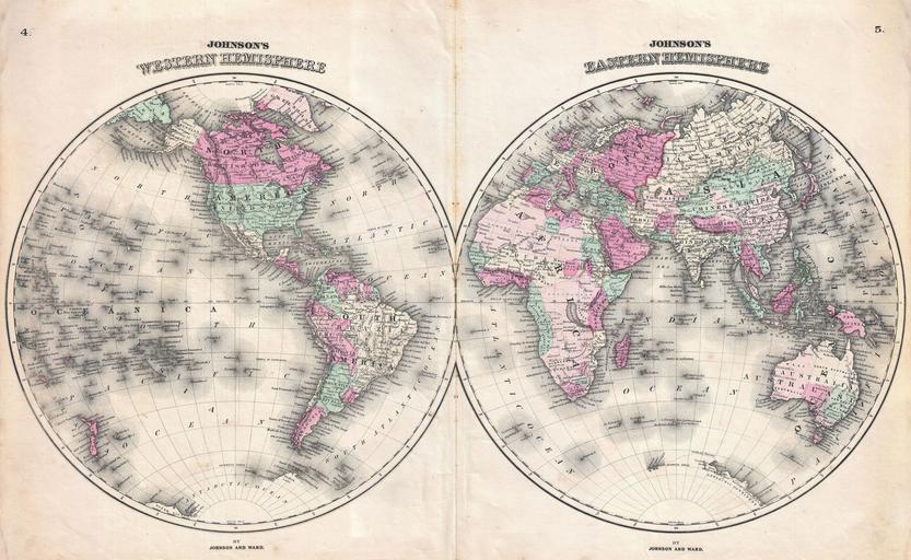
| Keywords: 1862 Johnson Map of the World on Hemisphere Projection - Geographicus - WorldHemi-johnson-1862.jpg This is A J Johnson ™s fine 1862 map of the world on a hemispherical projection Offers a fascinating snapshot of the world during a period of rapid globalization and discovery Africa is largely unexplored though Lake Uniamesi something that may be taken for an embryonic form of Lake Victoria Lake Tanganyika or both does appear This curious lake supposedly identified by Speak was frequently written of in mid century missionary reports as the source of several important African river stystems including the Congo The Antarctic continent is shown only sketchily representing the relatively primitive state of Antarctic exploration in 1862 Published by A J Johnson and Ward as plate numbers 4 and 6 in the 1862 edition of Johnson ™s New Illustrated Family Atlas This is the first edition of the Johnson ™s Atlas to bear the Johnson Ward imprint 1862 undated Size in 26 5 15 5 object history credit line accession number s Geographical Statistical and Historical </i> 1862 A J Johnson Ward edition Geographicus-source PD-old-100 Maps by Alvin Jewett Johnson 1862 maps Old maps of Earth's hemispheres | ||||