MAKE A MEME
View Large Image
| View Original: | 1862_Johnson_Map_of_Massachusetts,_Connecticut_and_Rhode_Island_-_Geographicus_-_MACTRI-johnson-1862.jpg (5000x3644) | |||
| Download: | Original | Medium | Small | Thumb |
| Courtesy of: | commons.wikimedia.org | More Like This | ||
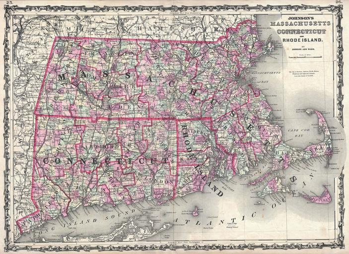
| Keywords: 1862 Johnson Map of Massachusetts, Connecticut and Rhode Island - Geographicus - MACTRI-johnson-1862.jpg This is Johnson and Ward ™s 1862 map of Massachusetts Connecticut and Rhode Island This rare map offers a fascinating snapshot of these two New England states shortly following the outbreak of the American Civil War Map shows all three states in full with bold and dramatic color coding according to county and district also details transportation routes especially roads railroads and canals Includes parts of Long Island East Hampton and Montauk as well as Nantucket Cape Cod and Martha ™s Vineyard Features the strapwork style border common to Johnson ™s atlas work from 1860 to 1863 Steel plate engraving prepared by A J Johnson for publication as plates no 25 and 26 in the 1862 edition of his New Illustrated Atlas ¦ This is the first edition of the Johnson ™s Atlas to bear the Johnson Ward imprint 1862 undated Size in 24 17 5 object history credit line accession number s Geographical Statistical and Historical </i> 1862 A J Johnson Ward edition Geographicus-source PD-old-100 Maps by Alvin Jewett Johnson 1862 maps Old maps of Connecticut Old maps of Massachusetts Old maps of Rhode Island | ||||