MAKE A MEME
View Large Image
| View Original: | 1855_U.S.C.S._Map_or_Chart_of_Washington_and_Oregon_-_Geographicus_-_WashingonOregon2-uscs-1855.jpg (5000x5487) | |||
| Download: | Original | Medium | Small | Thumb |
| Courtesy of: | commons.wikimedia.org | More Like This | ||
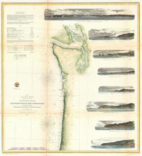
| Keywords: 1855 U.S.C.S. Map or Chart of Washington and Oregon - Geographicus - WashingonOregon2-uscs-1855.jpg One of the most attractive coastal charts of the western United States A rare hand colored 1855 coastal chart of the coastline of the United States Pacific Northwest including the modern day states of Washington and Oregon Map extends from the Oregon-California border northward to Vancouver Island and the Straits of Juan de Fuca Features eight coastal views Cape Perpetua N by w ½ W Cape Lookout N by W Tillamook Head N by W ½ W Sail Rock Destruction Island N W Flattery Rocks N W by N Tatoosh I North and Entrance to Columbia River Cape Disappointment E by N Depths sounding all along the coast with various points harbors and lookouts well noted Upper Left quadrant features tidal notations and sailing instructions Inland Steilacoom Olympia and Seattle are all noted on the Puget Sound The hydrography for this region was accomplished by James Alden and the geography by G Davidson Published under the supervision of A D Bache for the 1864 Report of the Superintendent of the U S Coast Survey 1855 dated Size in 25 22 object history credit line accession number WashingonOregon2-uscs-1855 <i>Report of the Superintendant of the U S Coast Survey </i> 1855 edition Geographicus-source PD-art United States Coast Survey maps Old maps of Washington state Old maps of Oregon 1855 maps | ||||