MAKE A MEME
View Large Image
| View Original: | 1855_Colton_Plan_or_Map_of_New_Orleans,_Louisiana_and_Louisville,_Kentucky_-_Geographicus_-_LouisvilleNewOrleans-colton-1855.jpg (3304x4000) | |||
| Download: | Original | Medium | Small | Thumb |
| Courtesy of: | commons.wikimedia.org | More Like This | ||
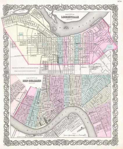
| Keywords: 1855 Colton Plan or Map of New Orleans, Louisiana and Louisville, Kentucky - Geographicus - LouisvilleNewOrleans-colton-1855.jpg A beautiful 1855 first edition example of Colton's rare two part map of New Orleans Louisiana and Louisville Kentucky Map is divided into two sections Both are hand colored in pink green yellow and blue pastels to identify city wards Both maps also offer extraordinary detail at level of individual streets and buildings Both maps are drawn to the same scale Surrounded by Colton's typical spiral motif border The lower map New Orleans Louisiana covers from Jefferson City to Benefit Street and from MacDonogh to Dolhonde Street In addition to all major streets this map identifies the New Orleans and Opelousas Rail Road Depot Mechanics Village Annunciation Square and Claiborne Canal The upper map Louisville Kentucky covers from Portland to Cave Hill Cemetery and from Oak Street to the Ohio River Identifies the Louisville and Frankfort Depot the City Marine Hospital the St Vincent Orphan Asylum the City Graveyard St Mary's Graveyard City Hall the Court House and the Medical College Dated and copyrighted to J H Colton 1855 Published from Colton's 172 William Street Office in New York City Issued as page no 34 in volume 1 of the first edition of George Washington Colton's 1855 Atlas of the World 1855 dated Size in 13 16 object history credit line accession number LouisvilleNewOrleans-colton-1855 Colton G W <i>Colton's Atlas of the World Illustrating Physical and Political Geography</i> Vol 1 New York 1855 First Edition Geographicus-source PD-old-100 Maps by Joseph Hutchins Colton Louisville Kentucky in the 1850s Maps of Louisville Kentucky Old maps of New Orleans 1855 maps 1855 in New Orleans Kentucky in the 1850s | ||||