MAKE A MEME
View Large Image
| View Original: | 1855_Colton_Plan_or_Map_of_Washington_D.C._-_Geographicus_-_WashingtonDC2-colton-1855.jpg (4000x3284) | |||
| Download: | Original | Medium | Small | Thumb |
| Courtesy of: | commons.wikimedia.org | More Like This | ||
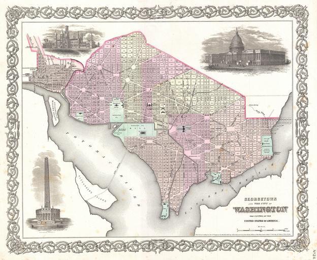
| Keywords: 1855 Colton Plan or Map of Washington D.C. - Geographicus - WashingtonDC2-colton-1855.jpg An excellent 1855 first edition example of Colton's rare map of Washington D C and Georgetown Covers the city in incredible detail from Georgetown Georgetown University then College shown in the upper left quadrant to Alexander ™s Island in the south and as far east as Magazine Warf Hand colored in pink green yellow and blue pastels with considerable detail at level of individual streets and buildings Surrounded by Colton's typical spiral motif border Reflects Pierre L'Enfant's brilliant city design showing the iconic grid and ray street layout Individual buildings such as the Smithsonian the White House the Capitol the Arsenal Penitentiary Naval Yard Poor House Asylum and Post office are all indicated Features three inset engravings The Smithsonian Institution the Capitol and a preliminary plan for the Washington Monument Dated and copyrighted to J H Colton 1855 Published as page no 24 in volume 1 of the first edition of George Washington Colton's 1855 Atlas of the World 1855 dated Size in 16 13 object history credit line accession number WashingtonDC2-colton-1855 Colton G W <i>Colton's Atlas of the World Illustrating Physical and Political Geography</i> Vol 1 New York 1855 First Edition Geographicus-source PD-old-100 Maps by Joseph Hutchins Colton Old maps of Washington D C 1855 maps | ||||