MAKE A MEME
View Large Image
| View Original: | 1855_Colton_Map_of_Peru_and_Bolivia_-_Geographicus_-_PeruBolivia-colton-1855.jpg (4000x3255) | |||
| Download: | Original | Medium | Small | Thumb |
| Courtesy of: | commons.wikimedia.org | More Like This | ||
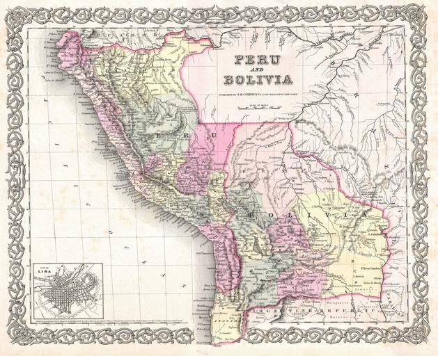
| Keywords: 1855 Colton Map of Peru and Bolivia - Geographicus - PeruBolivia-colton-1855.jpg An excellent first edition example of Colton's rare 1855 map Peru and Bolivia Covers from Ecuador to the Argentine Republic and from the Pacific to Brazil Shows Bolivia's claims to the Atacama desert and Peru's claims to Moquegua - both of which are today part of Chile An inset detail map of Lima Peru appears in the lower left quadrant Throughout the map Colton identifies various cities towns forts rivers rapids fords and an assortment of additional topographical details Map is hand colored in pink green yellow and blue pastels to define national and regional boundaries Surrounded by Colton's typical spiral motif border Dated and copyrighted to J H Colton 1855 Published as page no 60 in volume 1 of the first edition of George Washington Colton's 1855 Atlas of the World 1855 dated Size in 16 13 object history credit line accession number PeruBolivia-colton-1855 Colton G W <i>Colton's Atlas of the World Illustrating Physical and Political Geography</i> Vol 1 New York 1855 First Edition Geographicus-source PD-old-100 Maps by Joseph Hutchins Colton Old maps of Peru Old maps of Bolivia 1855 maps | ||||