MAKE A MEME
View Large Image
| View Original: | 1855_Colton_Map_of_Columbia,_Venezuela_and_Ecuador_-_Geographicus_-_VenezuelaColumbia-colton-1855.jpg (4000x3323) | |||
| Download: | Original | Medium | Small | Thumb |
| Courtesy of: | commons.wikimedia.org | More Like This | ||
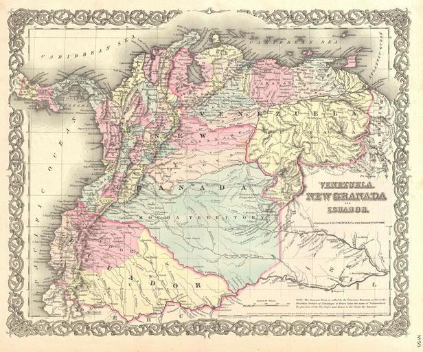
| Keywords: 1855 Colton Map of Columbia, Venezuela and Ecuador - Geographicus - VenezuelaColumbia-colton-1855.jpg An excellent first edition example of Colton's rare 1855 map Venezuela New Granada Columbia and Ecuador Covers from the Pacific to Guyana and from Peru to the Caribbean Includes Panama Offers notes an various indigenous groups naming numerous tribes Throughout the map Colton identifies various cities towns forts rivers rapids fords and an assortment of additional topographical details Map is hand colored in pink green yellow and blue pastels to define national and regional boundaries Surrounded by Colton's typical spiral motif border Dated and copyrighted to J H Colton 1855 Published as page no 59 in volume 1 of the first edition of George Washington Colton's 1855 Atlas of the World 1855 dated Size in 16 13 object history credit line accession number VenezuelaColumbia-colton-1855 Colton G W <i>Colton's Atlas of the World Illustrating Physical and Political Geography</i> Vol 1 New York 1855 First Edition Geographicus-source PD-old-100 Maps by Joseph Hutchins Colton Old maps of the Republic of New Granada Old maps of Ecuador Old maps of the history of Venezuela 1855 maps | ||||