MAKE A MEME
View Large Image
| View Original: | 1855_Colton_Map_of_Bavaria,_Wurtemberg_and_Baden,_Germany_-_Geographicus_-_Germany3-colton-1855.jpg (3500x2810) | |||
| Download: | Original | Medium | Small | Thumb |
| Courtesy of: | commons.wikimedia.org | More Like This | ||
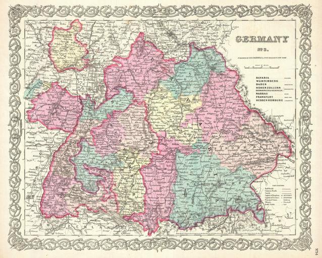
| Keywords: 1855 Colton Map of Bavaria, Wurtemberg and Baden, Germany - Geographicus - Germany3-colton-1855.jpg A beautiful 1855 first edition example of Colton's map of southern Germany Covers the 19th century German provinces of Bavaria Wurttemberg Baden and Pfalz as well as numerous smaller regions Divided and color coded according to regional divisions Throughout Colton identifies various cities towns forts rivers and assortment of additional topographical details Surrounded by Colton's typical spiral motif border Dated and copyrighted to J H Colton 1855 Published from Colton's 172 William Street Office in New York City Issued as page no 14 in volume 2 of the first edition of George Washington Colton's 1855 Atlas of the World 1855 dated Size in 16 5 13 object history credit line accession number Germany3-colton-1855 Colton G W <i>Colton's Atlas of the World Illustrating Physical and Political Geography</i> Vol 2 New York 1855 First Edition Geographicus-source PD-old-100 Maps by Joseph Hutchins Colton 1855 maps 19th-century maps of Germany Old maps of Hesse Old maps of Rhineland-Palatinate 19th-century maps of Baden-Württemberg 19th-century maps of Bavaria | ||||