MAKE A MEME
View Large Image
| View Original: | 1855_Colton_Map_of_the_Arctic_or_North_Pole_-_Geographicus_-_NorthernRegions-colton-1855.jpg (3314x4000) | |||
| Download: | Original | Medium | Small | Thumb |
| Courtesy of: | commons.wikimedia.org | More Like This | ||
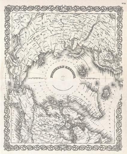
| Keywords: 1855 Colton Map of the Arctic or North Pole - Geographicus - NorthernRegions-colton-1855.jpg This rare hand colored map is a copper plate engraving dating to 1855 by the well known 19th century American Mapmaker J H Colton It is a representation of the North Pole and is formally titled Northern Regions This is a rare and historically important map as the polar regions were still relatively unexplored when it was drafted The Northwest and Northeast Passages are delineated and most of the coastlines of North America Europe and Asia are shown with relative accuracy Published from J H Colton ™s 172 William Str Office in New York 1855 dated Size in 13 16 object history credit line accession number NorthernRegions-colton-1855 <i>Colton's Atlas Of The World Illustrating Physical And Political Geography By George W Colton </i> 1855 or 1856 edition Geographicus-source PD-old-100 Maps by Joseph Hutchins Colton North Pole 1855 maps | ||||