MAKE A MEME
View Large Image
| View Original: | 1853_U.S.C.S._Map_of_the_Virginia_Coast_(_Gargathy_to_Machipongo_)_-_Geographicus_-_SeaCoastVirginiaNo2-uscs-1853.jpg (3059x3801) | |||
| Download: | Original | Medium | Small | Thumb |
| Courtesy of: | commons.wikimedia.org | More Like This | ||
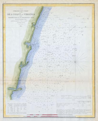
| Keywords: 1853 U.S.C.S. Map of the Virginia Coast ( Gargathy to Machipongo ) - Geographicus - SeaCoastVirginiaNo2-uscs-1853.jpg Offered is a U S Coast Survey map or chart of the Virginia coastline from Gartathy Inlet to Gr Machipongo Inlet Includes several of Virginia ™s barrier islands specifically Hog Island Paramore ™s Island and Cedar Island Numerous nautical notes and depth soundings dominate the right-hand side of the map This map was created under the direction of A D Bache Superintendent of the Survey of the Coast of the United States and one of the most influential American cartographers of the 19th century 1853 Size in 12 10 object history credit line accession number SeaCoastVirginiaNo2-uscs-1853 Geographicus-source PD-art United States Coast Survey maps Old maps of Virginia 1853 maps | ||||
_-_Geographicus_-_SeaCoastVirginiaNo2-uscs-1853.jpg)