MAKE A MEME
View Large Image
| View Original: | 1853_Mitchell_Map_of_Turkey_in_Europe_and_Greece_(_Greece,_Balkans,_Macedonia_)_-_Geographicus_-_TurkeyEurope-mitchell-1850.jpg (2445x3000) | |||
| Download: | Original | Medium | Small | Thumb |
| Courtesy of: | commons.wikimedia.org | More Like This | ||
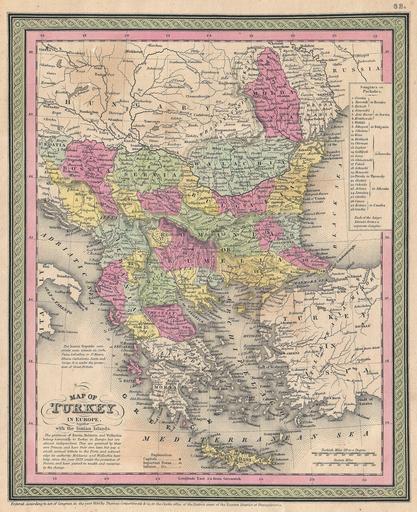
| Keywords: 1853 Mitchell Map of Turkey in Europe and Greece ( Greece, Balkans, Macedonia ) - Geographicus - TurkeyEurope-mitchell-1850.jpg An extremely attractive example of S A Mitchell Sr ™s 1853 map of Turkey in Europe This map made when the Ottoman Empire controlled much of the region covers what is today Turkey Greece Macedonia Croatia Bosnia Serbia Romania Bulgaria Macedonia and Albania Ottoman provinces are color coded and numbered Surrounded by the green border common to Mitchell maps from the 1850s Prepared by S A Mitchell for issued as plate no 62 in the 1853 edition of his New Universal Atlas Dated and copyrighted Entered according to act of Congress in the year 1850 by Thomas Cowperthwait Co in the Clerks office of the District court of the Eastern District of Pennsylvania 1850 dated Size in 10 12 5 object history credit line accession number TurkeyEurope-mitchell-1850 <i>A New Universal Atlas Containing Maps of the various Empires Kingdoms States and Republics Of The World </i> 1853 issue Geographicus-source PD-old-100 Maps by Samuel Augustus Mitchell Old maps of Europe Old maps of Greece 1853 maps Maps in English | ||||
_-_Geographicus_-_TurkeyEurope-mitchell-1850.jpg)