MAKE A MEME
View Large Image
| View Original: | 1853_Andrews_Map_of_the_Maritime_Provinces,_New_Brunswick,_Nova_Scotia,_Newfoundland_-_Geographicus_-_MaritimeProvinces-andrews-1853.jpg (5000x2772) | |||
| Download: | Original | Medium | Small | Thumb |
| Courtesy of: | commons.wikimedia.org | More Like This | ||
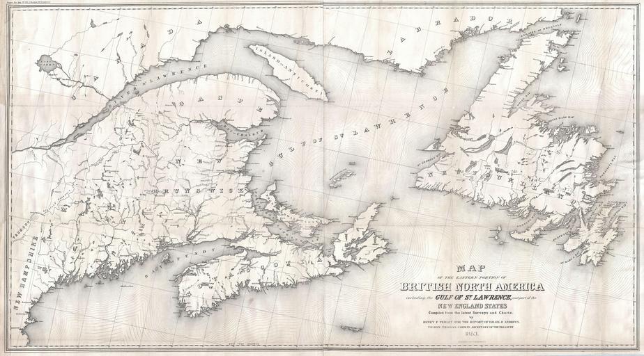
| Keywords: 1853 Andrews Map of the Maritime Provinces, New Brunswick, Nova Scotia, Newfoundland - Geographicus - MaritimeProvinces-andrews-1853.jpg A rare beautiful and gigantic map of the Canadian Maritime Provinces of New Brunswick Nova Scotia Newfoundland and Prince Edwards Island Also includes much of Quebec and parts of New York and New England Depicts from Quebec City and the mouth of the St Lawrence River eastward to the Maritime Provinces Offers magnificient detail with regard to the towns cities and rivers systems of this area Prepared by Henry Pearley for Israel D Andrews ™ Report to the Secretary of the Treasury 1853 dated Size in 47 26 object history credit line accession number MaritimeProvinces-andrews-1853 <i>Communication from the Secretary of the Treasury transmitting in compliance with a resolution of the Senate of March 8 1851 the Report of Israel D Andrews consul of the United States for Canada and New Brunswick on the Trade and Commerce of the British North American Colonies and upon the Trade of the Great Lakes and Rivers; also notices of the internal imporvements in each state of the Gulf of Mexico and the Straits of Florida and a Paper on the Cotton Crop of the United States </i> 1853 editon Geographicus-source PD-art Old maps of the Gulf of Saint Lawrence Old maps of New Brunswick Old maps of Nova Scotia Old maps of Newfoundland Old maps of Prince Edward Island 1853 maps of Canada | ||||