MAKE A MEME
View Large Image
| View Original: | 1852_Levasseur_Map_of_the_Department_De_Saone_Et_Loire,_France_(Burgundy_or_Bourgogne_Wine_Region)_-_Geographicus_-_SaoneEtLoire-levasseur-1852.jpg (3500x2526) | |||
| Download: | Original | Medium | Small | Thumb |
| Courtesy of: | commons.wikimedia.org | More Like This | ||
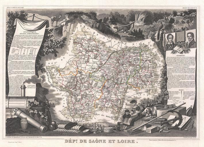
| Keywords: 1852 Levasseur Map of the Department De Saone Et Loire, France (Burgundy or Bourgogne Wine Region) - Geographicus - SaoneEtLoire-levasseur-1852.jpg This is a fascinating 1852 map of the French department of Saone et Loire France Part of France's important Burgundy or Bourgogne Wine Region Produces Mercurey and Givry among other red wines Around Mâcon are whites of fine quality notably Rully Montagny and also Pouilly-Fuissé a dry heady wine with much bouquet The map proper is surrounded by elaborate decorative engravings designed to illustrate both the natural beauty and trade richness of the land There is a short textual history of the regions depicted on both the left and right sides of the map Published by V Levasseur in the 1852 edition of his Atlas National de la France Illustree 1852 undated Size in 17 12 object history credit line accession number SaoneEtLoire-levasseur-1852 Levassuer V <i>Atlas National Illustre des 86 Departements et des Possessions de La France Divise par Arrondissements Cantons et Communea avec La Trace de Toutes Les Routes Chemins de fer et Canaux </i> 1852 edition Geographicus-source PD-old-100 <gallery>File 1847 Levasseur Map of Saone et Loire France - Geographicus - SaoneLoire-levasseur-1847 jpg</gallery> 1852 maps France Old maps of Saône-et-Loire Victor Levasseur - Maps of France France | ||||
_-_Geographicus_-_SaoneEtLoire-levasseur-1852.jpg)