MAKE A MEME
View Large Image
| View Original: | 1852_Levasseur_Map_of_the_Department_Des_Pyrenees_Orientales,_France_(Muscat_Wine_Region)_-_Geographicus_-_PyreneesOrles-levasseur-1852.jpg (3500x2527) | |||
| Download: | Original | Medium | Small | Thumb |
| Courtesy of: | commons.wikimedia.org | More Like This | ||
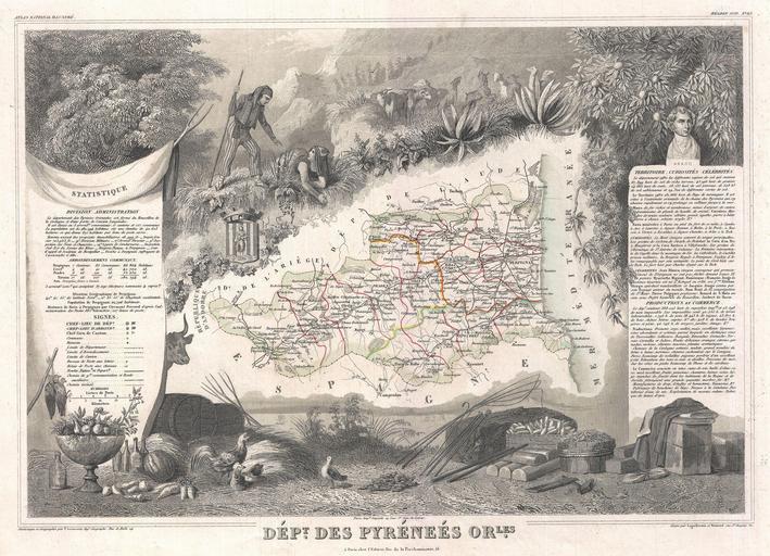
| Keywords: 1852 Levasseur Map of the Department Des Pyrenees Orientales, France (Muscat Wine Region) - Geographicus - PyreneesOrles-levasseur-1852.jpg This is a fascinating 1852 map of the French department of Pyrenees Orientales France This area is well-known wine producing region A wide variety of wines come out of this region including the famous Muscat wine This wine can be tasted as an aperitif or with dessert It pairs especially well with Roquefort cheeses The map proper is surrounded by elaborate decorative engravings designed to illustrate both the natural beauty and trade richness of the land There is a short textual history of the regions depicted on both the left and right sides of the map Published by V Levasseur in the 1852 edition of his Atlas National de la France Illustree 1852 undated Size in 16 5 11 5 object history credit line accession number PyreneesOrles-levasseur-1852 Levassuer V <i>Atlas National Illustre des 86 Departements et des Possessions de La France Divise par Arrondissements Cantons et Communea avec La Trace de Toutes Les Routes Chemins de fer et Canaux </i> 1852 edition Geographicus-source PD-old-100 1852 maps France Old maps of Pyrénées-Orientales Maps of Perpignan coat of arms François Arago Victor Levasseur - Maps of France France | ||||
_-_Geographicus_-_PyreneesOrles-levasseur-1852.jpg)