MAKE A MEME
View Large Image
| View Original: | 1852_Levasseur_Map_of_the_Department_Des_Basses_Pyrenees,_France_(Jurancon_Wine_Region)_-_Geographicus_-_BassesPyrenees-levasseur-1852.jpg (3500x2581) | |||
| Download: | Original | Medium | Small | Thumb |
| Courtesy of: | commons.wikimedia.org | More Like This | ||
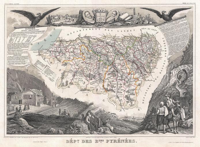
| Keywords: 1852 Levasseur Map of the Department Des Basses Pyrenees, France (Jurancon Wine Region) - Geographicus - BassesPyrenees-levasseur-1852.jpg This is a fascinating 1852 map of the French department of Basses Pyrenees France This department includes the Jurancon wine region famous for its production dry wines and sweet white wines The famous Pilgrimage to Santiago de Compostella passes through this heavily Basque region ultimately crossing the Pyrenees into Spain at St Jean Pied-de-Port The map proper is surrounded by elaborate decorative engravings designed to illustrate both the natural beauty and trade richness of the land There is a short textual history of the regions depicted on both the left and right sides of the map Published by V Levasseur in the 1852 edition of his Atlas National de la France Illustree 1852 undated Size in 16 11 5 object history credit line accession number BassesPyrenees-levasseur-1852 Levassuer V <i>Atlas National Illustre des 86 Departements et des Possessions de La France Divise par Arrondissements Cantons et Communea avec La Trace de Toutes Les Routes Chemins de fer et Canaux </i> 1852 edition Geographicus-source PD-old-100 1852 maps France Old maps of Pyrénées-Atlantiques Symbols of Pau coat of arms People with donkeys in art Historical images of Eaux-Bonnes view at lower left Victor Levasseur - Maps of France France | ||||
_-_Geographicus_-_BassesPyrenees-levasseur-1852.jpg)