MAKE A MEME
View Large Image
| View Original: | 1852_Levasseur_Map_of_the_Department_Du_Lot,_France_(Cahors_Wine_Region)_-_Geographicus_-_Lot-levasseur-1852.jpg (3500x2437) | |||
| Download: | Original | Medium | Small | Thumb |
| Courtesy of: | commons.wikimedia.org | More Like This | ||
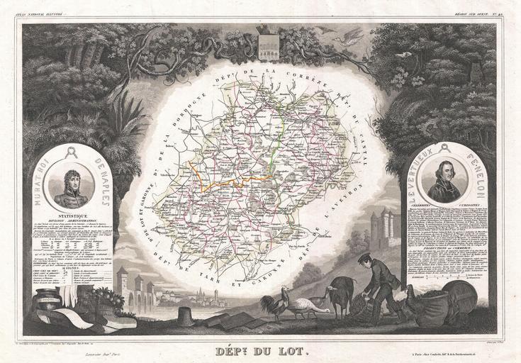
| Keywords: 1852 Levasseur Map of the Department Du Lot, France (Cahors Wine Region) - Geographicus - Lot-levasseur-1852.jpg This is a fascinating 1852 map of the French department of Lot France This area of France is known for its production of Cahors wine a powerful red wine often harsh when young but remarkable after a few years in bottle The Pilgrimage to Santiago de Compostella also passes through the northern part of this region The map proper is surrounded by elaborate decorative engravings designed to illustrate both the natural beauty and trade richness of the land There is a short textual history of the regions depicted on both the left and right sides of the map Published by V Levasseur in the 1852 edition of his Atlas National de la France Illustree 1852 undated Size in 17 5 12 object history credit line accession number Lot-levasseur-1852 Levassuer V <i>Atlas National Illustre des 86 Departements et des Possessions de La France Divise par Arrondissements Cantons et Communea avec La Trace de Toutes Les Routes Chemins de fer et Canaux </i> 1852 edition Geographicus-source PD-old-100 Victor Levasseur - Maps of France France 1852 maps France Old maps of Lot | ||||
_-_Geographicus_-_Lot-levasseur-1852.jpg)